Understanding and Assessing Impacts
The site surrounding Dale Hodges Park sits at the outfall location of a large underground stormwater system discharging into the Bow River upstream of a bull trout spawning area. This presented environmental and hydrological opportunities, but also infrastructural complexities to the project.
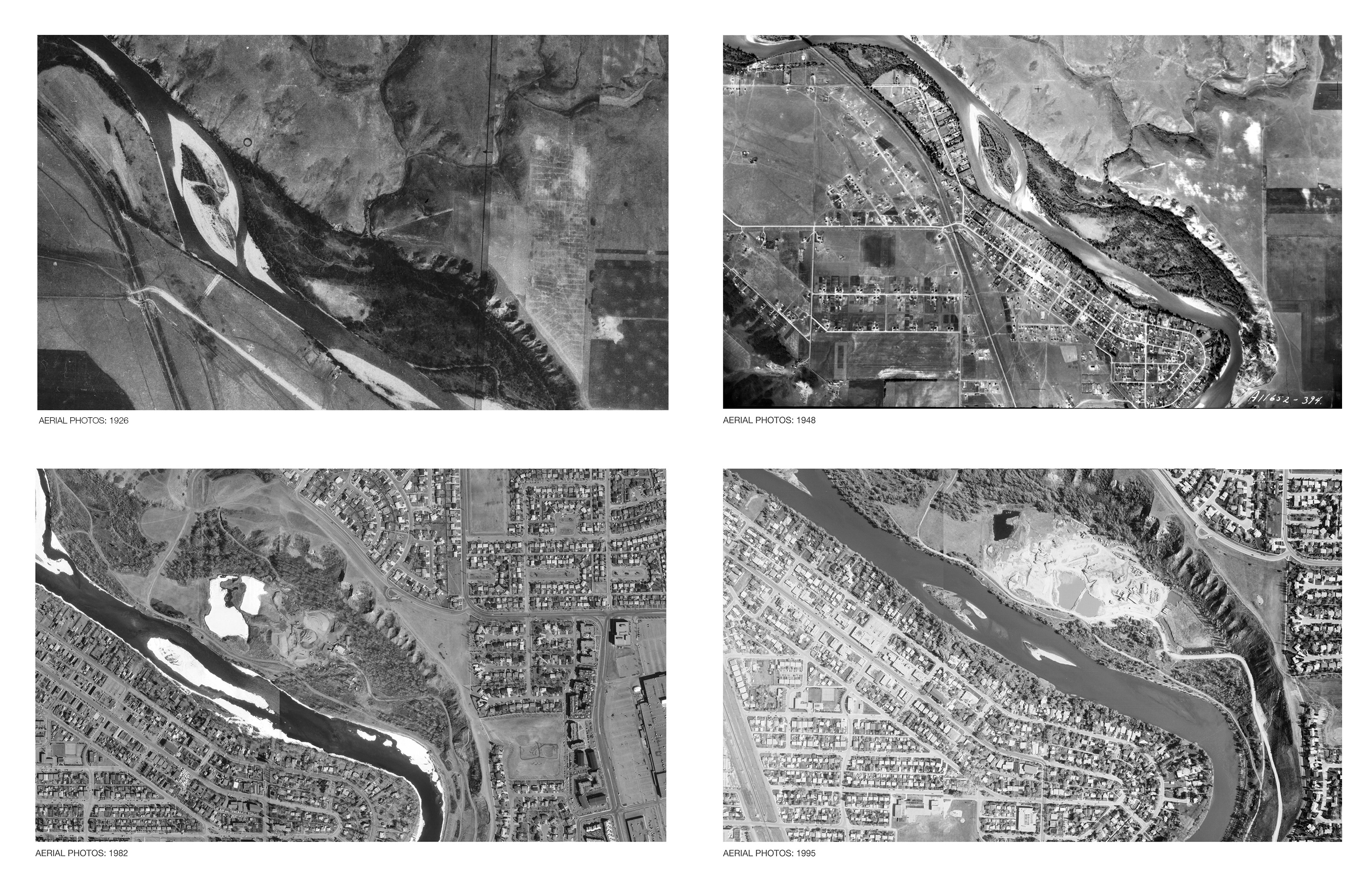
The riverine, riparian and valley escarpment ecosystems of the Bow River Valley are among the most important natural features in Calgary. The Bow River is a cold, clear mountain river, and has a unique trout-oriented stream ecology. Before the area became a gravel pit in the mid-20th century, it historically contained a natural stream channel. However, warming and pollution led to reduced oxygen levels and nutrient enrichment, which significantly impacted the trout stream and ecological health.
To address water quality concerns and the ecological degradation of the site, the principal objectives of the project were the treatment of stormwater before entering the Bow River, and the restoration of the ecosystem. This project presented an opportunity to regenerate the native habitats, restore the historical hydrological system, reconnect people to the river through recreation and park amenities, and to demonstrate municipal commitments to environmental sustainability.
Use of climate data in decision-making:
A series of studies and analysis of existing conditions, including site hydrology, vegetation, habitat quality, current uses and infrastructure, and utilities and stormwater, were conducted.
At the center of the project is the stormwater management system, designed to adapt to a range of flow conditions, from frequent low-flow events to extreme flooding. This flexibility reflects climate projections for Southern Alberta, which indicate that both the frequency and intensity of storm events will increase. At the downstream area, the design integrates an erosion-resistant spillway that functions as a safety valve during high-water or backflow events. This feature enhances the ecological function and protects both the stormwater structure and the surrounding habitat from damage.
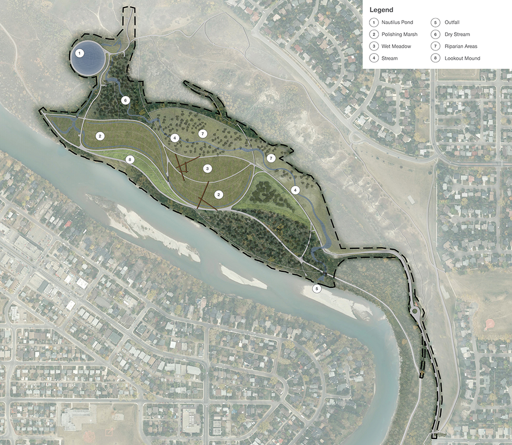
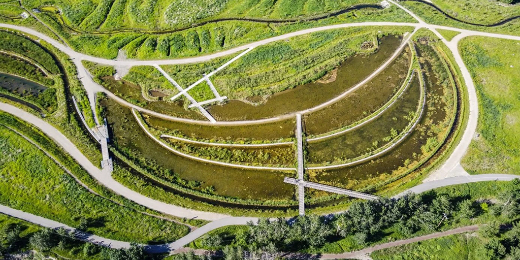
The stormwater treatment system is organized into nine treatment cells, each designed with unique soil conditions, plant communities, and hydrological characteristics. This diversity of ecologies enhances water quality and supports the natural regeneration of habitat across deep and shallow marsh zones. Likewise, the varied hydrologic conditions and plant interactions foster biodiversity and provide habitat for a wide range of species.
The flow of water within the park begins in the upstream residential communities where runoff travels through pipes before daylighting in the park, passing through built structures and streams into a series of polishing marshes, wet meadows, riparian areas and a 900 meter long restored stream. At the upper reaches of the constructed stream, stormwater enters the Nautilus Pond which removes a high proportion of sediments and floating contaminants that would otherwise overwhelm more sensitive components of the system downstream. Flows up to 5 cubic metres per second (cm/s), are then directed through the riparian forest and into the constructed stream that runs along the wetland complex, where it receives further treatment for finer sediments, dissolved nutrients and other contaminants. Infrequent major flows, in excess of 5 cm/s up to ~20 cm/s, bypass the treatment wetland and receive treatment by the constructed stream and riparian habitats in biomimicry of beneficial flooding events. This deliberate reconnection of hydrology restores the forest’s natural flood cycle by allowing silt deposition and nutrient cycling to occur, creating a productive riparian ecosystem.
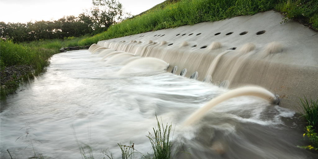
A dual-pipe system is used to accommodate both small and large storm events, where smaller pipes manage routine flows but carry higher overall pollutant loads, and larger pipes are activated during major storm events. Upper “Source Walls” (a term coined by the artists to describe the installation) are engaged during extreme rainfall by releasing rainwater prior to entering the Nautilus Pond or allowing water overflow to return to the stream without disrupting the wetland system. These walls also serve as public art making, allowing visitors to witness the fluctuations of the water levels during different storm events.
Aerial imagery timeline, 1926–1995.
Source walls