Low Impact Development Infrastructure Performance and Risk Assessment Pilot in Brampton

Starting in 2015, Credit Valley Conservation (CVC) began a monitoring pilot to assess the impact of Low Impact Development (LID) stormwater management strategies that provide enhanced water quality and quantity treatment.

Located in the City of Brampton, the Wychwood Subdivision was the first subdivision in the Credit River Watershed to use a LID only stormwater management system in place of a stormwater pond. As such, this subdivision was utilized as a study site for the Low Impact Development Infrastructure Performance and Risk Assessment Pilot to address priority monitoring objectives identified in the Credit Valley Conservation Stormwater Management Monitoring Strategy.

CVC’s Infrastructure Performance and Risk Assessment (IPRA) program is a multi-year stormwater monitoring program designed to evaluate the performance of stormwater management infrastructure across various land uses, climate conditions, and real-world scenarios. The program monitors and evaluates LID features that CVC and partner municipalities have implemented on both public and private land.

The Wychwood Subdivision has a unique design addressing all stormwater criteria through distributed LID features within municipal right of ways and residential lots. As a result, land that would otherwise have been reserved for a pond can be used to build additional homes. The seventy-lot residential development manages stormwater runoff using permeable pavers, an infiltration trench, rain gardens and a bioswale.

Performance monitoring results from Wychwood found that:

  • Low impact development features provide 77% volume reductions for events up to 25 mm.
  • There was 84% load reduction of total suspended solids (TSS), exceeding the site’s specific stormwater management water quality criteria of 80% TSS removal.
  • For events greater than 30mm, peak flows were reduced on average by 74%, with a total volume reduction of 59%.

The findings show LID systems can provide resilience under large and intense rainfall events, to support meeting flood control targets, and erosion control criteria.

Understanding and Assessing Impacts

Historical climate data from Person International Airport was used to compare the historical records of the number and type of events collected at our climate station near Wychwood over the two-year monitoring period. The purpose is to determine if the events collected represent historical norms across the region. Understanding the relative contributions of events of different sizes to annual rainfall is important for interpreting performance results.

Stormwater management practices such as wet detention ponds have been in place for more than 30 years. A study conducted by the Lake Simcoe Region Conservation Authority (LSRCA) surveyed ponds ranging in age from two to 23 years. Of the 98 ponds surveyed, 77 were designed to meet Level 1 criteria (the most stringent type of quality control with 80% phosphorus reduction). Only 36 ponds (less than half) were still operating at Level 1 efficiency.

As of 2018, there were 180 ponds within the City of Brampton stormwater infrastructure inventory and estimates suggest that approximately 400 ponds will exist at build out when Brampton has reached its municipal development boundaries. Preventative and corrective maintenance costs for stormwater ponds can vary depending on the work required. Ongoing pond inspection is the most common maintenance cost accrued and can cost anywhere between $713 and $1425 per inspection depending on staff salary. Once a stormwater pond reaches its full sediment load, the settled material must be removed and disposed of to maintain the pond’s sediment removal design storage. Sediment removal and disposal costs range from $53 to $513 per cubic metre of sediment removed.

In addition to budget implications, there is evidence that stormwater ponds are not completely alleviating peak flows from urban areas at the watershed scale. Furthermore, stormwater ponds do not control the volume of water discharged to receiving streams; rather, ponds delay the discharge of stormwater flows. Streamflow data from Brampton indicates that while stormwater ponds do reduce peak flow from individual ponds to receiving streams, the cumulative impact can still result in peak flows that are up to two orders of magnitude higher than pre-development peak flow conditions, despite the use of ponds.

The addition of sustained funding from a stormwater charge in Brampton’s municipal budget will help maintain stormwater assets in the near term, however, based on studies from LSRCA and CVC, funding gaps will remain if stormwater ponds continue to be the preferred method of managing stormwater.
Identifying Actions

For more than 10 years, CVC’s IPRA program has monitored LID’s ability to provide flood control, erosion protection, nutrient removal, cold weather performance, and maintenance of pre-development water balance. This information helps municipalities:

  • Identify opportunities to reduce stormwater risks, and plan for and justify future infrastructure investments.
  • Develop measures to improve water runoff quality, protect receiving stream habitats, and support stormwater management in tablelands upstream of flood zones.
  • Inform climate change strategies: the program can supply metrics to help measure the mitigation of stormwater runoff impacts over time. Performance monitoring includes maintenance inspection and tracking to record the frequency and extent of maintenance activities during a stormwater feature’s life cycle.
  • Guide development of municipal asset management programs in adherence to Ontario Regulation 588/17 by 2024. While typical asset management programs focus on asset condition and operational needs such as inspections and maintenance, monitoring programs can also build an understanding of maintenance needs and conditions assessments of existing stormwater assets.

Performance monitoring of LID designs have observed reductions in runoff volumes and delays in measured outflow rates, thereby reducing pressures on downstream stormwater infrastructure and receiving waters. Benefits of LID include a reduction in the monetary value of flood losses, increased developable land (5-7%) due to the absence of a stormwater management pond, as well as improvements to water quality and quantity. The Wychwood Subdivision provides an opportunity to educate urban municipalities on how to balance growth, stormwater infrastructure, and the environment in light of climate change.

Implementation

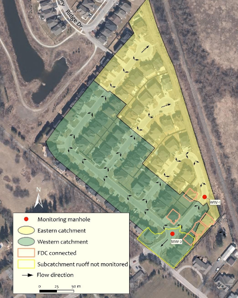
Monitoring data was collected from two years of onsite stormwater monitoring from January 2016 to December 2017. During the modelling and the stormwater monitoring process, CVC reviewed and re-analyzed the catchment area footprint of the Wychwood subdivision. Arc hydro Geographical Information Software and Lidar analysis were used to delineate the discrete catchment area for each LID feature. A new total site catchment area of 4.09 hectares was determined to be more accurate for estimating runoff from the site. This catchment area is used to determine inflows for determining overall stormwater management performance (see figure below).

The monitoring program for the Wychwood Subdivision included the collection of precipitation and flow data, as well as outflow water temperature and water quality data, from the LID sites installed within the east catchment and west catchment. The analysis included an examination of the hydrologic responses for events of various magnitudes at each monitoring location. Performance is assessed, based on peak flow reduction, lag time and an emphasis on the estimated runoff volume reduction.

Using these indicators on an event by event bases, CVC compared monitoring results with the approved stormwater management design criteria for the subdivision. These include:

  • Water quality control – Enhanced water quality treatment per the Ministry of Environment Stormwater Management Planning and Design Manual, i.e. long-term removal of 80% suspended solids
  • Erosion control – Manage, detain or reuse all rainfall events up to the 15 mm storm event over the entire site
  • Water quantity control – Reduce the 2 to 100-year post-development flows to pre-development levels
  • Water balance – Retain the average annual infiltration depth to pre-development levels.

The above design criteria is used in comparison with post-development models and onsite monitoring data to assess the overall performance of Wychwood stormwater features. Modelling has been used as an evaluation tool for water quantity control and water balance criteria but has also been used to check monitoring results and inflow estimation.

CVC staff also conducted site inspections to visually document performance and maintenance across all seasons while the features are in service. Ten site inspections have been carried out during the monitoring period. These inspections documented the property alterations made by homeowners that increased the impervious ratio across the subdivision, contributing to greater runoff from the residential lots. An in-depth description of monitoring metrics and analysis can be found in the case study report linked below.

Wychwood Subdivision Site Cachement Area

Continuous data collection monitoring locations

Image of a sustainable urban rainwater management project in the City of Vancouver. The schematic includes incorporation of greenscaping as a way of not only beautifying the streetscape, but also to provide functional purposes such as rainwater management and small areas of habitat refugia. The image shows the integration of sustainable design with climate adaptation actions. Specific foci are on the inclusion of more city street trees, native plants, areas for pollinators, rain gardens, and the creation of common spaces for gathering.

Outcomes and Monitoring Progress

Of the total number of measured events (125) during the monitoring period, 112 had a precipitation depth of less than 25 mm. These events make up 90% of all precipitation events for the 2016 and 2017 monitoring period at Wychwood, which aligns with the long-term average of 95% at Pearson Airport. Monitoring also observed a 77% volume reduction and 83% flow reduction is achieved by the site LID features for events less than 25 mm. Since these events occur most frequently, they are responsible for transporting a large proportion of the annual contaminant mass delivered to receiving waters. Therefore, their management is critical to achieving water quality objectives.

Observed performance for Total Suspended Solids (TSS) load reduction from the total site monitoring station is 84%, with the bioswale achieving a total estimated load reduction of 99%. Overall, the Wychwood Subdivision exceeds the target of 80% TSS removal, and the bioswale alone greatly exceeds this target.

Event monitoring during the study period determined the erosion control criterion to manage, detain or reuse all events up to 15 mm has not been achieved. A range of events producing ~15 mm of precipitation with varying intensities occurred during the monitoring period. These events produced outflows at the total site monitoring station. Design deficiencies have been identified as contributing factors in performance reduction. Changes in lot-level pervious area, lag-time between events and limited infiltration rates due to a high groundwater table within one of the LID features have been identified as potential contributors to performance reduction. Despite this, there are no observed concerns regarding overall site water quantity erosion control, peak flow attenuation or water quality treatment.

Next Steps

Monitoring at Wychwood (including the recommended addition of groundwater monitoring in 2020) will continue to assess the long-term performance of the LID features. The addition of groundwater monitoring wells will provide details on the influence of high groundwater levels on runoff storage, infiltration and peak flow attenuation with corresponding surface flow monitoring information. Site inspections will continue to document changes to the site and help evaluate long-term performance and maintenance needs of the LID features with the goal of developing guidance on life-cycle costs and asset management. This comprehensive data set will provide further insight into the long-term performance of infiltration features in areas with site constraints such as high groundwater levels.

CVC will continue to support Brampton to provide asset management training based on observation at Wychwood that can apply to other LID designs across the municipality. Ramping up stormwater asset management programs across municipalities is critical to extending the life of stormwater assets and supports the City’s objectives of providing a high level of services for its constituents.