Understanding and Assessing Impacts
To inform trail planning and design, Mills & Wright conducted a series of comprehensive assessments that included: community mapping to document key cultural features and community population profiles; a review of relevant municipal planning policies and long-term frameworks; a review of climate data to understand regional climate projections, sea-level rise, and coastal hazards; an extensive trail analysis to determine trail alignments, infrastructure vulnerabilities and accessibility; field work to observe site conditions; and documenting best practices and emerging adaptation design strategies in trail and recreation planning.
Community engagement was critical to the assessment process, and included a community open house held in May 2023 and an online survey to gather feedback from residents and trail users. Gaining community support for rerouting the trail to a more protected location was a key objective, requiring meaningful dialogue and engagement to build a greater understanding of the potential long-term climate risks to the community. The engagement process revealed other key priorities that informed design decisions, such as trail realignment and construction, wayfinding elements, accessibility, environmental considerations, drainage and surface conditions, as well as the need for supporting amenity features including benches, picnic tables, and washrooms.
The trail inventory assessment also provided critical information for understanding the trail’s condition and was used to identify culturally-defining features, opportunities and challenges, and elements requiring protection, enhancement, or both. Town staff and council members accompanied the Mills & Wright design team during portions of the inventory process, contributing insights on pre-Fiona conditions. This inventory process helped the design team document flora and fauna, topography and surface materials, significant natural and built features, viewpoints, ecological connectivity, and public access.
In addition to the inventory assessment, ecological assessments also provided an understanding of ecological conditions and helped to identify habitat and sensitive or significant areas. Prior to Hurricane Fiona, the beaches at Grand Bay West featured some of the most intact and ecologically significant sand dunes and intertidal zones on the island of Newfoundland. Importantly, these sand dunes provide natural coastal protection and serve as nesting grounds for the piping plover, an endangered bird species. While the sand dunes and wetlands were expected to gradually recover naturally, the redeveloped infrastructure was sited away from these areas to prevent disrupting natural ecosystem regeneration, and additional habitat protection measures were included in the Renewal Plan to support ecological processes without interference.
Use of Climate Information in Decision-Making
Newfoundland and Labrador is already experiencing the effects of climate change, with rising average temperatures, increased frequency of extreme weather events, and escalating impacts from coastal erosion, sea-level rise, and storm surges – impacts that are often disproportionately experienced in smaller rural communities, where limited resources and capacity heighten vulnerabilities. In western and southern Newfoundland, sea levels are projected to rise by 80–90 centimetres over the next century, amplifying risks to the community and the coastal and marine ecology.
Integrating climate data into the trail renewal project enabled the design team at Mills & Wright to evaluate potential risks, and prioritize resilient solutions and ideas to ensure that the strategies outlined in the Renewal Plan address both current vulnerabilities and long-term projected climate impacts. To do so, the design team reviewed a range of resources on climate change including The Way Forward: On Climate Change in Newfoundland and Labrador, as well as the Coastal Change in Newfoundland and Labrador: A Handbook for Policy Makers and the Public (2020). These documents provided critical insight into the anticipated changes in the region and informed design strategies for the trail network, revealing four key areas of coastal impact: more frequent and severe storms, storm surges, flooding, and erosion.
Aerial imagery from a geospatial data visualization tool, EagleView Canada, provided the design team with critical insights on pre- and post-hurricane conditions by mapping storm surge extents, erosion areas, and inland impacts. The observed impacts from Hurricane Fiona and the storm surge levels were then overlaid with projected climate data to inform decision-making. This visualization method provided a compelling and accessible way to communicate climate data, with areas more likely to be affected by storm damage clearly identified and avoided in the new trail alignment.
Since the completion of the Grand Bay West Trail Renewal Plan, Newfoundland and Labrador has developed two complementary Climate Change Action Plans: the 2025-2030 Climate Change Mitigation Plan; and the 2025-2030 Climate Change Adaptation Plan. Together, these documents will guide efforts and assist communities, government, and organizations in advancing resilience and adaptation to minimize risk and manage impacts of anticipated climate changes.
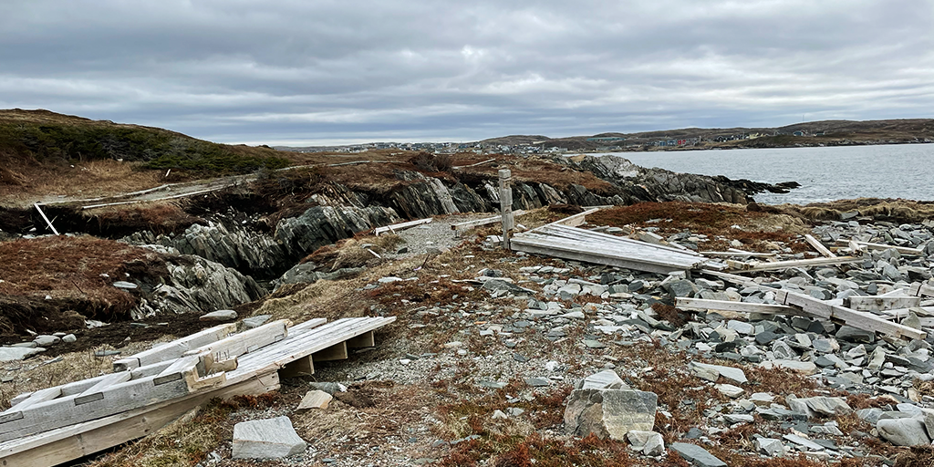
Shoreline lookout damage following Hurricane Fiona
Shoreline lookout damage following Hurricane Fiona