Eeyou Istchee Coastal Climate Change Adaptation and Environmental Emergency Preparedness Workshop

The workshop took place in the Cree Nation of Chisasibi, focusing on a coastal perspective to climate change adaptation and environmental emergency preparedness. The first two days of the workshop were devoted to going through a step-by-step adaptation planning process, where the Cree Nation of Chisasibi served as a case study, but with the objective for each participant to acquire the necessary knowledge to replicate the process in their own community. The third day of the workshop focused on environmental emergency preparedness, where mock emergency situations were explored to understand appropriate processes for potential emergency events. The link between climate change and emergency preparedness is direct, and so the three-day workshop provided a space to explore these connections and plan for the future. The workshop was also the first in person meeting of the Climate Change Advisory Committee, bringing together the communities and Cree entities within Eeyou Istchee to help share insights and experiences, ensuring regional cohesion. Participants spent three days sharing observations and experiences, informing and developing adaptation and emergency preparedness planning.

Understanding and Assessing Impacts

Stemming from past regional climate change events, the climate change adaptation and emergency preparedness workshop aimed to answer regional needs, developing local and regional climate adaptation plans, and enhance environmental emergency management coordination.  

Use of Climate Information

The Canadian Centre for Climate Services worked with the Cree Nation Government, Cree Board of Health and Social Services of James Bay and Ouranos to provide select climate information for the region of Eeyou Istchee and the territory of Chisasbi. The information considers the six Cree Seasons as well as the 12-month calendar to facilitate a discussion on adaptation at the community level. In most cases, annual climate indices are disaggregated to the corresponding Cree season where the change will be experienced. 

Data was presented, discussed and then used to inform adaptation planning. This included regional data for Eeyou Istchee and community data for Chisasibi.

Plotting impacts of Climate Change

Image of a sustainable urban rainwater management project in the City of Vancouver. The schematic includes incorporation of greenscaping as a way of not only beautifying the streetscape, but also to provide functional purposes such as rainwater management and small areas of habitat refugia. The image shows the integration of sustainable design with climate adaptation actions. Specific foci are on the inclusion of more city street trees, native plants, areas for pollinators, rain gardens, and the creation of common spaces for gathering.

Identifying Actions

Collaboration with project partners: 

  1. Establish the “Workshop Steering Committee” to plan the workshop. Steering committee members included representatives from Cree Nation Government, Cree Board of Health and Social Services of James Bay, Cambium Indigenous Professional Services, and Environment and Climate Change Canada.  
    • The steering committee worked to plan and facilitate the workshop, identifying the connections between climate change adaptation and emergency planning to widen the focus of the workshop. Delegating tasks, acquiring funding, developing presentations and general logistics were the focus of the committee.  
  1. Establishment of the Climate Change Advisory Committee (CCAC), which includes representatives from the 9 communities of the Cree Nation of Eeyou Istchee, regional entities and other stakeholders with the secretariat being the Cree Nation Government.  The CCAC was established with a working mandate to: 
    • support CNG and advise leadership on climate-related issues 
    • develop and support implementation of emission reduction, adaptation, and preparedness projects, plans, and strategies – locally and regionally 
    • engage with stakeholders to promote sustainable practices, increase knowledge, and strengthen climate resilience across Eeyou Istchee.

Implementation

Virtual Introduction 

To prepare participants for the in-person training, virtual training(s) with the newly established Climate Change Advisory Committee took place a few weeks before the in-person workshop. This virtual training served as an introduction to the method and process being used during the in-person workshop, reviewing the Climate Change Adaptation Plan approach and process from Georgina Island First Nation, as well as an overview of the climate data being used for the workshop in Chisasibi.  
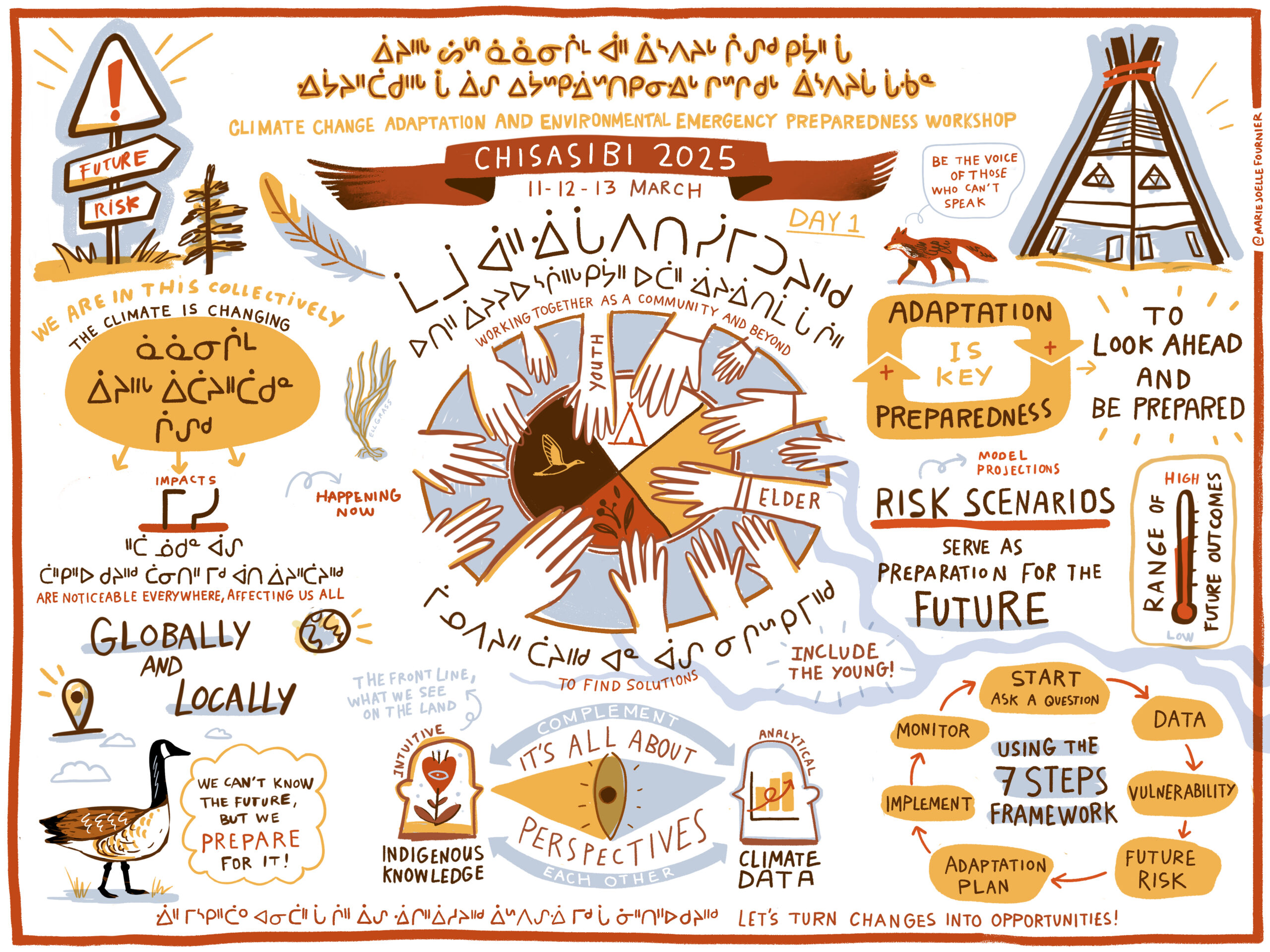
Day 1 of workshop: 

Opening and introduction, roundtable, sharing: 

Every attendee participated in a roundtable of introductions and sharing of their perspectives and priorities.   

  • Caribou and white moss decline 
  • Snow falling before ground is frozen 
  • Hydro dam bursting (fear) 
  • Forest fire 
  • Unsafe ice 
  • Rain in January 
  • Decrease of salinity in water 

Presentations: 

  • Adaptation Planning in Action in Georgina Island (used this process as a template for adaptation planning throughout workshop) 
    • Georgina Island and Land Relationship Visioning overview 
    • Framework overview 
  • Climate Change 101 & Data Projections 
    • Western climate data 
    • Colonialism and climate change  
    • What is climate change and climate data 
  • Regional Climate Change Vulnerability Assessment 
    • Process behind vulnerability assessment  
    • Quantifying Indigenous knowledge to understand vulnerability through an adaptation tool.  
  • Climate Forum Overview on Climate Adaptation Priorities 
    • Overview of CNG climate change unit and forum  
  • Environmental Emergency Preparedness 
    • Firefighting v. forest fire fighting  
    • Training and equipment maintenance, 
    • Lines of communication  

Discussions after presentations before lunch.  

Activity directions and handout interpretation: 

  • CCCS presentation about climate data booklets (how to read/use) 
  • Conversation ensued, participants asked CCCS about climate data, discussions around observations on the land the connections to the data being presented.  
  • Conversation continued until the end of the day.  
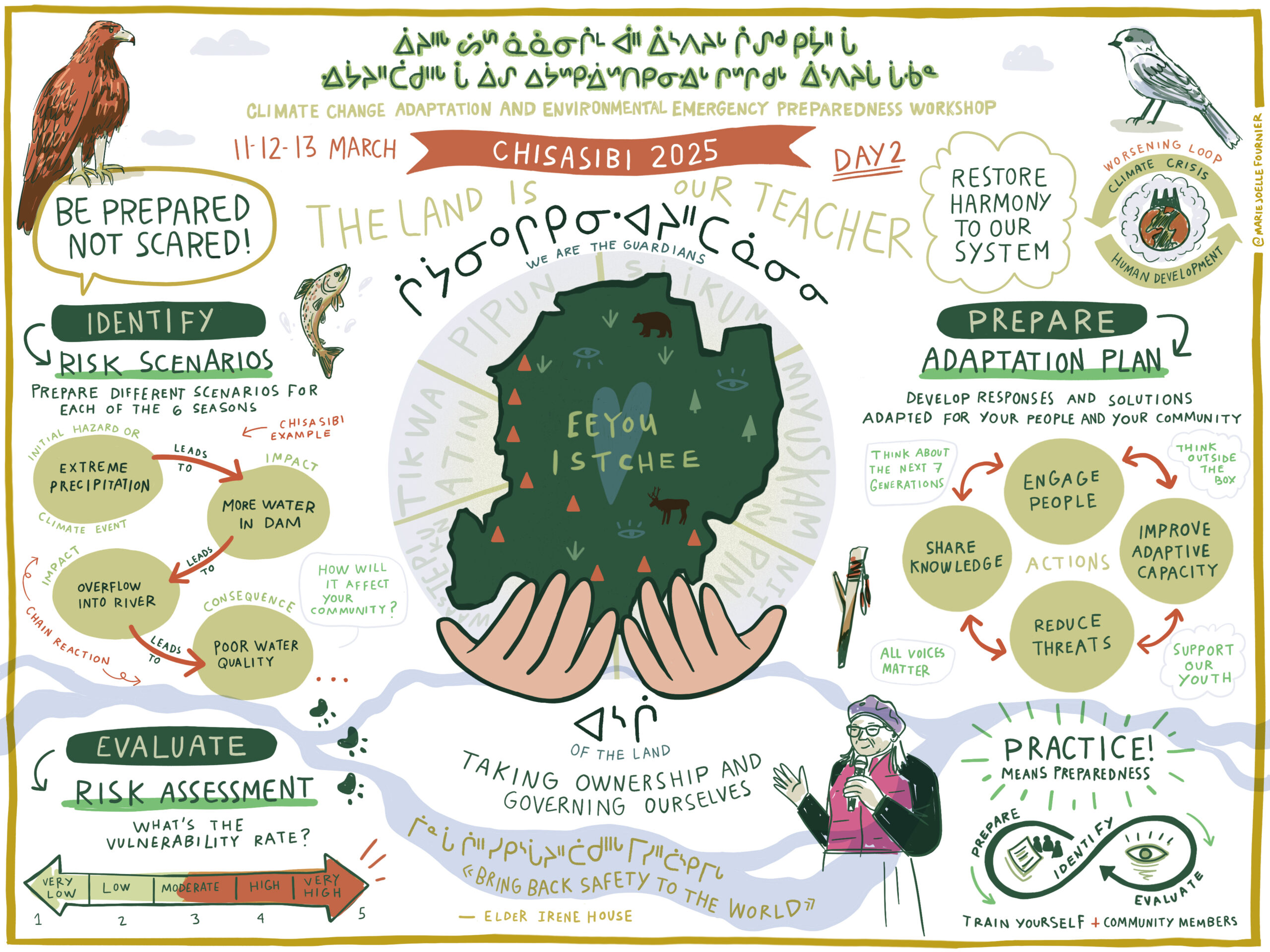
Day 2 of workshop: 

Activities deviated from the agenda to ensure enough time was allocated for the risk scenarios workshop and to begin adaptation planning based off understanding the risks.  

  • Day One Recap 
  • Likelihood and Consequences Exercise 
  • Climate Data Workbook Presentation and Introduction  
    • Climate data workbooks developed by CCCS, one for the broader Eeyou Istchee Territory and then another for Chisasibi specifically.  
    • Data was presented in context with the Cree Calendar and the six seasons within that calendar.  
    • The intention was that workshop participants use the projected data to understand potential risks and consequences associated with those risks.  
  • Workshop: Risk Scenarios 
    • Risks were identified and then groups were formed based on region and relevance to each other, (a group for Chisasibi, a table with public safety/health representatives, etc.)  
    • Each group was given a risk to evaluate, groups had group leaders – representatives of the CCAC – as a “train the trainer” attempt, so that individuals had the experience facilitating the discussions. The objective of that was for the CCAC group facilitator to gain facilitation skills so that they could replicate the workshop discussions in their home Communities in the development of their own adaptation plan.  
      • Group leaders used markers and a flip-chart to document the discussion where risks were identified and discussed. 
      • Discussions were summarized and shared back to the wider group.  

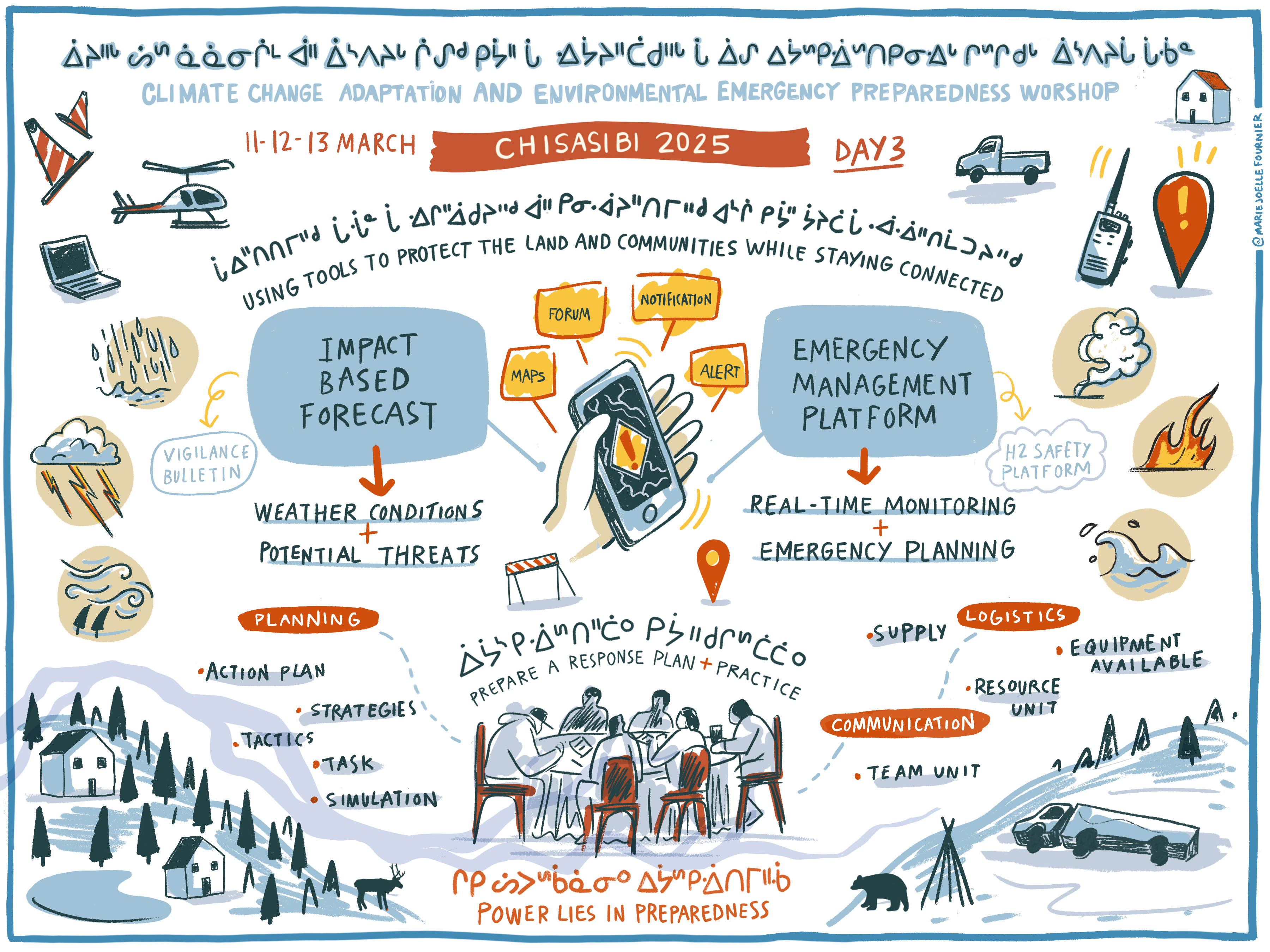
Day 3: Environmental Emergency Preparedness 

Day 3 was dedicated to environmental emergency preparedness, understanding the interconnectedness between Climate Change preparedness and emergency preparedness. Tabletop exercises addressing various potential scenarios, communications and coordination were facilitated for participants to gain an in depth understanding of the processes in the case of emergency. 

Day one graphic illustration

Image of a sustainable urban rainwater management project in the City of Vancouver. The schematic includes incorporation of greenscaping as a way of not only beautifying the streetscape, but also to provide functional purposes such as rainwater management and small areas of habitat refugia. The image shows the integration of sustainable design with climate adaptation actions. Specific foci are on the inclusion of more city street trees, native plants, areas for pollinators, rain gardens, and the creation of common spaces for gathering.
Day two graphic illustration

Image of a sustainable urban rainwater management project in the City of Vancouver. The schematic includes incorporation of greenscaping as a way of not only beautifying the streetscape, but also to provide functional purposes such as rainwater management and small areas of habitat refugia. The image shows the integration of sustainable design with climate adaptation actions. Specific foci are on the inclusion of more city street trees, native plants, areas for pollinators, rain gardens, and the creation of common spaces for gathering.
Day three graphic illustration

Image of a sustainable urban rainwater management project in the City of Vancouver. The schematic includes incorporation of greenscaping as a way of not only beautifying the streetscape, but also to provide functional purposes such as rainwater management and small areas of habitat refugia. The image shows the integration of sustainable design with climate adaptation actions. Specific foci are on the inclusion of more city street trees, native plants, areas for pollinators, rain gardens, and the creation of common spaces for gathering.

Outcomes and Monitoring Progress

The workshop served as a practical way for training and capacity building to develop adaptation plans in Communities across Eeyou Istchee. Additional outcomes from the workshop were the ability to network and share in discussion observations. Having CCCS/Climate Data Scientists in Community, allowed for the pairing in real time of TEK/Land observations with the science/data presented. One very important/highlighted conversation was when a participant was talking about how the land had physically changed over time, as if it was rising. This was something not entirely understood within the Community until CCCS was able to validate the observation by explaining vertical land motion (isostatic rebound) – which was then confirmed by an elder.

Other discussions had:  

  • Deeper understanding of forest fire/uncontrolled fire consequences on natural environment, including air quality and carbon monoxide
  • Discussions around changes in species observations and timing of seasonal activities including changes in weather and snow fall/melt
  • Discussions around impacts to species and ensuring any rehabilitation/restoration is forward thinking that includes ecosystem/species within
  • The differences and similarities between adaptation and mitigation, how they are related and feed into one another
  • Impacts to mental health for land practitioners when the land is changed and/or access is limited

The workshop was an overall success, that allowed different representatives from the Climate Change Advisory Committee to take a leading role in facilitating conversation that identified risks. A graphic illustrator was on site to document discussions and activities, with the final illustration incorporating the Cree language. The workshop had many benefits outside of practical adaptation planning, and served as an opportunity for regional connection and cohesion.  

Graphic designer sketching illustration concepts

Image of a sustainable urban rainwater management project in the City of Vancouver. The schematic includes incorporation of greenscaping as a way of not only beautifying the streetscape, but also to provide functional purposes such as rainwater management and small areas of habitat refugia. The image shows the integration of sustainable design with climate adaptation actions. Specific foci are on the inclusion of more city street trees, native plants, areas for pollinators, rain gardens, and the creation of common spaces for gathering.

Next Steps

  • Participants to return home and begin adaptation planning process in their respective communities
  • CCAC continue to meet and communicate about regional needs and processes
  • A follow up workshop in Cree Nation of Mistissini scheduled for inland communities, to follow similar flow of workshop but adapted to specific needs in Cree Nation of Mistissini