County Court Sustainable Neighbourhood Action Program (SNAP): Climate Ready County Court

‘Climate Ready County Court’ is a neighbourhood-scale vulnerability assessment and adaptation plan co-created by residents and stakeholders to prepare for local climate change impacts and set the stage for collaborative action. Located in Brampton’s south end, the County Court neighbourhood is home to about 5,800 people of diverse backgrounds and cultures. Climate Ready County Court is a collaboration between Toronto and Region Conservation Authority (TRCA)’s Sustainable Neighbourhood Action Program (SNAP) and Ontario Climate Consortium Secretariat (OCC), City of Brampton, Region of Peel, County Court Neighbourhood Association (CCNA) and Infrastructure Ontario. Creative and future-oriented community engagement activities were used to identify local knowledge, create a personal connection to local climate futures, and support capacity building in local residents. As identified by the community and stakeholders, the local climate risks and vulnerabilities include increasing temperatures, heat stress, low tree canopy coverage and more frequent and severe weather events (e.g. ice, wind, rain, heat). Through the adaptation planning process, 13 adaptation strategies were identified by the community and are planned for implementation. Climate Ready County Court is part of a broader initiative called the County Court Sustainable Neighbourhood Action Plan, developed as part of TRCA’s broader SNAP program. County Court SNAP is a comprehensive environmental improvement plan that integrates local community interests into urban renewal and climate action, with implementation of cross cutting projects and programs underway.

Understanding and Assessing Impacts

Climate Ready County Court is one of the first vulnerability assessment and adaptation plans to be done at the neighbourhood scale in Canada. The project is a collaboration between TRCA, City of Brampton, Region of Peel, County Court Neighbourhood Association and Infrastructure Ontario. It seeks to combine local knowledge with broader local and regional vulnerability assessments and sector-based studies. Climate Ready County Court seeks to create understanding of local climate-related risks and vulnerabilities, and to identify adaptation strategies to avoid or mitigate potential impacts. The analysis of climatic impacts and risk and vulnerability characterization was part of Phase 2 of the project, which included a technical review of climatic data as well as mapping exercises. The assessment methodology was based on the Urban Community Resilience Assessment Framework, which was developed to help practitioners take an integrated approach to assessing vulnerability within a specific region, allowing the ability to link city-level resilience planning with the priorities of local residents. In this case, the process also builds on the local County Court Sustainable Neighbourhood Action Plan (SNAP) that is currently underway.

Community engagement and resident capacity building were critical to the development of the Vulnerability Assessment and Adaptation Plan. Activities built on the community connections developed through the broader County Court SNAP initiative, and key stakeholders and active residents were closely involved in all stages. During Phase one, a review of best practices in climate community engagement was undertaken to help design an innovative and meaningful engagement approach. Identified local risks and vulnerabilities for County Court include increasing heat stress; low tree canopy coverage; extreme wind and weather events causing higher risk to homes; lack of awareness regarding climate impacts and emergency preparedness activities; communication barriers due to a significant portion of non-English-speaking residents; increasing isolation; and limited mobility from a lack of trails and pathways around the eastern portion of the neighbourhood. This project also aims to create a personal connection to local climate futures and create a shared plan using creative, inspiring, and future oriented activities.
Identifying Actions

The development of the Vulnerability Assessment and Adaptation climate plan involved four key phases. Phase one began in Fall 2018 with system characterization (e.g., compilation of municipal-scale vulnerability assessments, identification of local assets and perceptions of risk); this phase incorporated broad stakeholder input. Phase two took place in Spring 2019 and involved an analysis of climate impact and vulnerability factors (e.g., technical review, mapping). Phase three took place in summer 2019 and involved the development of adaptation strategies and projects (e.g., framework development, engagement process, synthesis). Phase four occurred in Fall 2019 and involved evaluation and final report writing (e.g., vulnerability reduction potential of retrofits, implementation directions, transfer of neighbourhood model). The plan addresses short- and long-term resilience by pulling together strategies for built and natural infrastructure, as well as emergency preparedness and community resilience. The plan sets the stage for collaborative efforts to drive actions on climate change adaptation within the County Court neighbourhood, as well as in City of Brampton and across the Region of Peel. There are several key objectives used in guiding this plan, including using local knowledge to inform broader City of Brampton and Region of Peel vulnerability assessments; create a sense of community, connection to climate issues, and supporting capacity-building among local residents and the County Court Neighbourhood Association (CCNA).

Implementation

Thirteen adaptation strategies were developed by the project partners and the community in order to address the climate risks and vulnerabilities facing the local neighbourhood, these adaptation strategy actions include: Splash pads and water fountains; Public and private tree planting and shade structures; Central hubs and gathering areas; Know your neighbour program; Neighbourhood emergency plan; Consider integrating designated heating/cooling; Integrated design of public realm; Consider establishing a multi-unit residential community garden; Leverage existing groups to increase engagement; Consider using faith-based programming; Energy conservation measures; Developing a climate resiliency checklist; and Green roofs and white roofs. To complement the final adaptation strategies, the project team created a set of adaptation designs to help visualize what these opportunities may look like, and to showcase the co-benefits and synergies in the landscape.

Site 1: County Court Park Adaptation Design

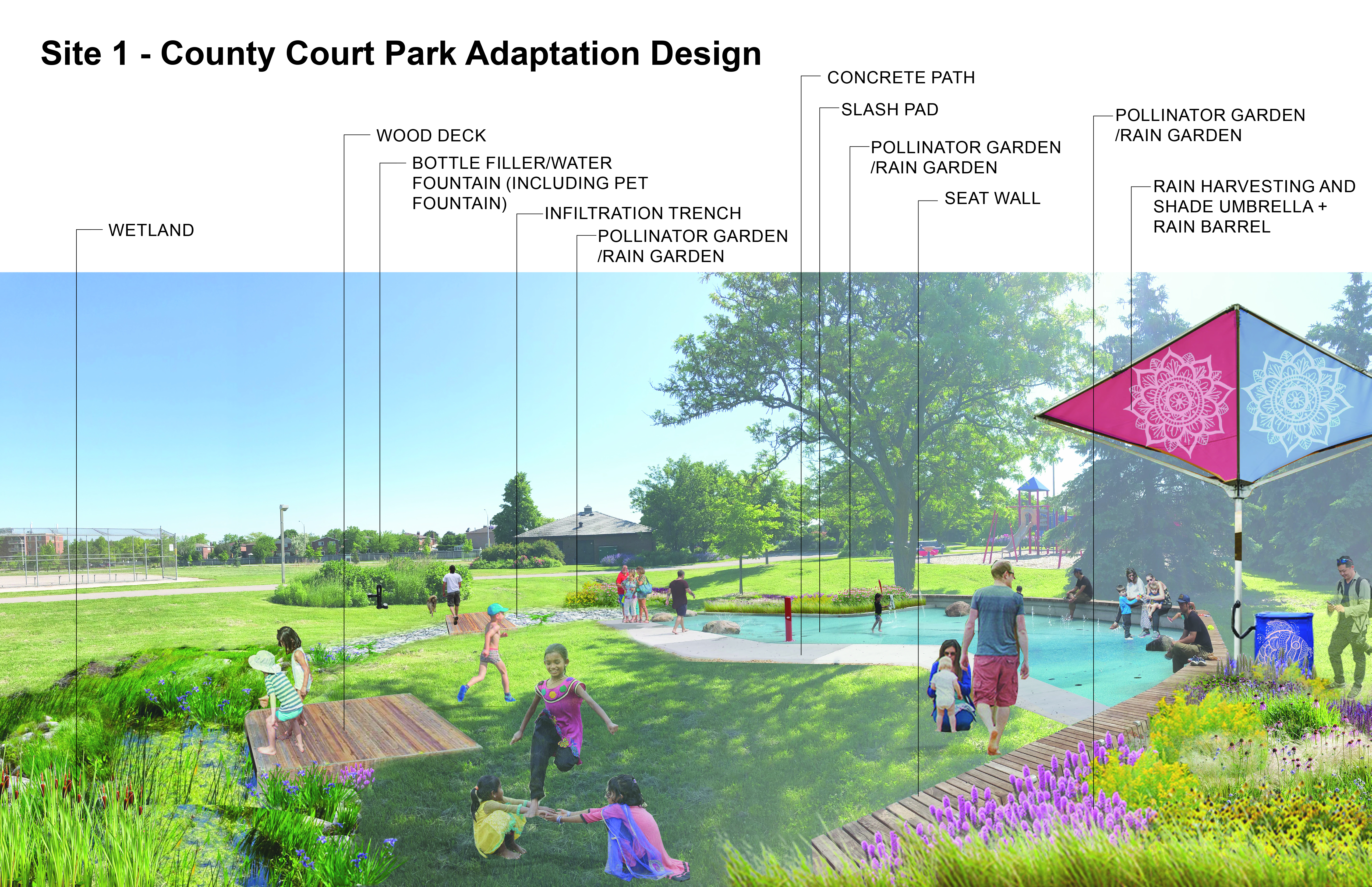
Image of a sustainable urban rainwater management project in the City of Vancouver. The schematic includes incorporation of greenscaping as a way of not only beautifying the streetscape, but also to provide functional purposes such as rainwater management and small areas of habitat refugia. The image shows the integration of sustainable design with climate adaptation actions. Specific foci are on the inclusion of more city street trees, native plants, areas for pollinators, rain gardens, and the creation of common spaces for gathering.

Site 2: Havelock Boulevard Adaptation Design

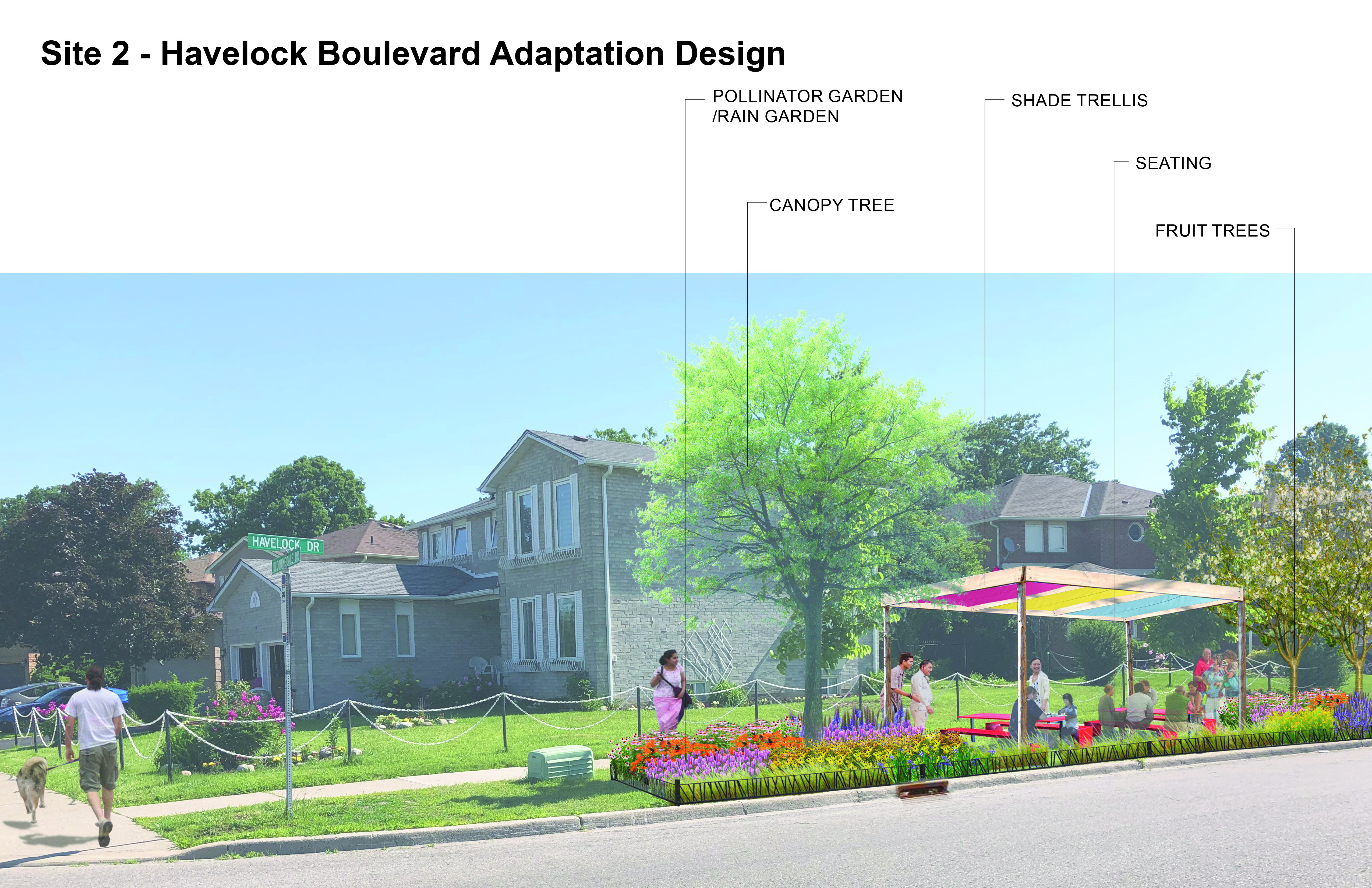
Image of a sustainable urban rainwater management project in the City of Vancouver. The schematic includes incorporation of greenscaping as a way of not only beautifying the streetscape, but also to provide functional purposes such as rainwater management and small areas of habitat refugia. The image shows the integration of sustainable design with climate adaptation actions. Specific foci are on the inclusion of more city street trees, native plants, areas for pollinators, rain gardens, and the creation of common spaces for gathering.
Site 3: Court House Parking Lot Adaptation Designs

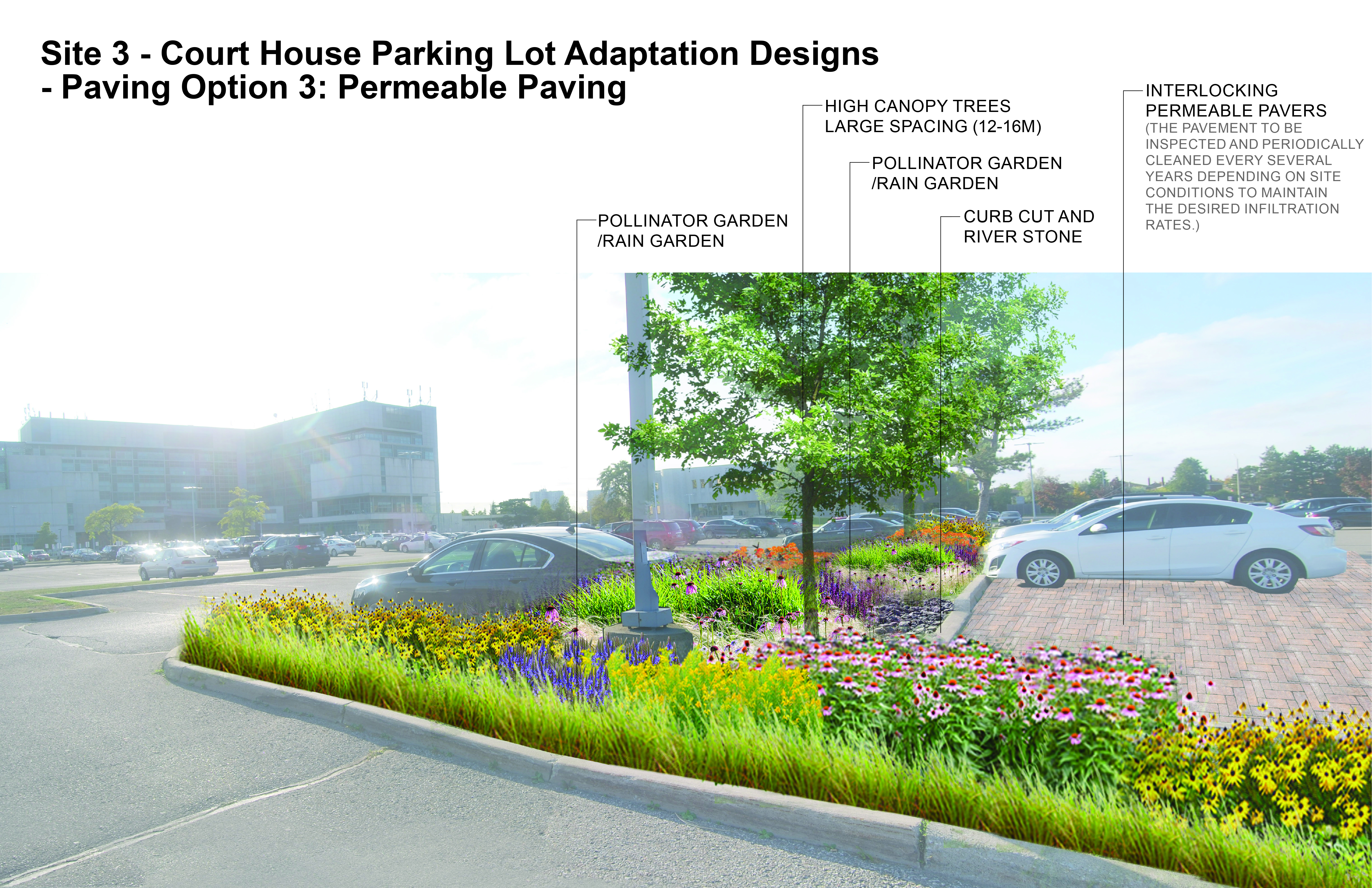
Site 3: Court House Parking Lot Adaptation Designs - Permeable interlocking brick pavers.

Image of a sustainable urban rainwater management project in the City of Vancouver. The schematic includes incorporation of greenscaping as a way of not only beautifying the streetscape, but also to provide functional purposes such as rainwater management and small areas of habitat refugia. The image shows the integration of sustainable design with climate adaptation actions. Specific foci are on the inclusion of more city street trees, native plants, areas for pollinators, rain gardens, and the creation of common spaces for gathering.

Outcomes and Monitoring Progress

Several key objectives, which will serve as outcomes of this project, include the aim to inform the final stages of SNAP implementation and refinement of municipal implementation; to serve as a framework to support neighbourhood-based adaptation planning as a component of TRCA’s SNAP program and beyond; and to support capacity-building among local residents and the County Court Neighbourhood Association (CCNA). Thirteen adaptation strategies were developed by the project partners and the community in order to address the climate risks and vulnerabilities facing the local neighbourhood, these adaptation strategy actions include: Splash pads and water fountains; Public tree planting and shade structures; Central hubs and gathering areas; Know your neighbour program; Neighbourhood emergency plan; Consider integrating designated heating/cooling; Integrated design of public realm; Consider establishing a multi-unit residential community garden; Leverage existing groups to increase engagement; Consider using faith-based programming; Energy conservation measures; Developing a climate resiliency checklist; and Green roofs and white roofs. To complement the final adaptation strategies, the project team created a set of adaptation designs to help visualize what these opportunities may look like, and to showcase the co-benefits and synergies in the landscape.

Next Steps

  • Project partners will look for opportunities to implement recommendations and showcase adaptation designs to support work at other sites
  • Community members taking the lead on community connections
  • Sharing lessons learned and applying this model in other SNAP neighbourhoods (i.e., Thornhill SNAP)

Resources

Link to Full Case Study

Additional Resources:

Using climate change projections enables better adaptation decisions, as it allows you to better understand how the climate may change. To learn how to choose, access, and understand climate data, visit ClimateData.ca’s Learning Zone.

Visit ClimateData.ca and click “Explore by Variable” for future climate projections related to temperature and precipitation, which can be used to inform adaptation planning.