Understanding and Assessing Impacts
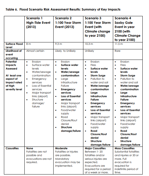
In 2010, the City of Moncton was selected to participate in the federal Regional Adaptation Collaborative (RAC) program (developed to identify and reduce the impacts of climate change). Through this partnership, a technical study, prepared by AMEC Earth and Environmental, was produced to help identify climate change trends and impacts for the Greater Moncton Area. The AMEC report identified more frequent storm events and increased risk of flooding as the main climate hazards in eastern Canada. After being presented the results of the RAC project (October 2012), Council requested that staff develop an action plan and flood management strategy by June 2013. Two key sources of data were used for this: 1. The Climate Change Adaptation Measures for Greater Moncton Area, NB report, and 2. New Brunswick’s Climate Futures data provided by the Atlantic Climate Adaptation Solutions Association. In the fall of 2012, the City of Moncton purchased rights to use emergency management software developed by the Canadian technology company Sentinel (http://www.sentinelsystems.ca/). Based on the findings of the AMEC report, the CCAC team assessed four types or potential flood scenarios for Moncton, including Scenario 1 (High tide event, 2013, 8m); Scenario 2 (1:100 year storm event, 2013, 9.3m); Scenario 3 (1:100 year storm event, with climate change to year 2100, 10.3m); and Scenario 4 (Saxby Gale event (with climate change to year 2100, 11.5m), with likelihood ratings reducing from the former to the latter. Afterwards, vulnerability and risk were assessed, which identified in what ways the city is most vulnerable to a flood event. These scenarios and risks provided a strategic approach to flood risk reduction and formed the foundation of this plan.
