Ward’s Creek Riparian Enhancement

In 2013, the Kennebecasis Watershed Restoration Committee (KWRC) developed the Ward’s Creek Riparian Enhancement initiative to address concerns over eroding banks and a degrading riparian habitat. Located in southern New Brunswick near Sussex, KWRC is a non-profit organization that works with all the rivers, streams and lakes that flow into the Kennebecasis River. The Kennebecasis River is a major tributary to the Lower Saint John River. Kennebecasis is a Maliseet term that means “little snake”, a good description for the river whose watershed covers 134,660 hectares, flowing through Sussex, Norton, Hampton, Quispamsis, Rothesay, and parts of Saint John. The main stem of the river is more than 90 kilometers long from the head of tide at Bloomfield to its source near Hamilton Lake, east of Sussex. KWRC’s mission is to advance habitat restoration, public awareness and participation and restore the Kennebecasis Watershed back to a sustainable ecosystem. The Kennebecasis River Watershed has a high percentage of agricultural land use (19%). Much of this land base is directly adjacent to rivers and streams in the watershed. Eroding stream banks and degrading riparian areas are a concern for both the agricultural community and the KWRC in the region, particularly in the context of a changing climate. Increased erosion can reduce available land for production, while warmer temperatures with less canopy coverage can increase water temperatures and may play a role in the introduction of new threats (e.g. invasive species) into the watershed. With the number of municipalities, recreational opportunities, as well as various corporate interests, the health of this watershed is important.

Understanding and Assessing Impacts

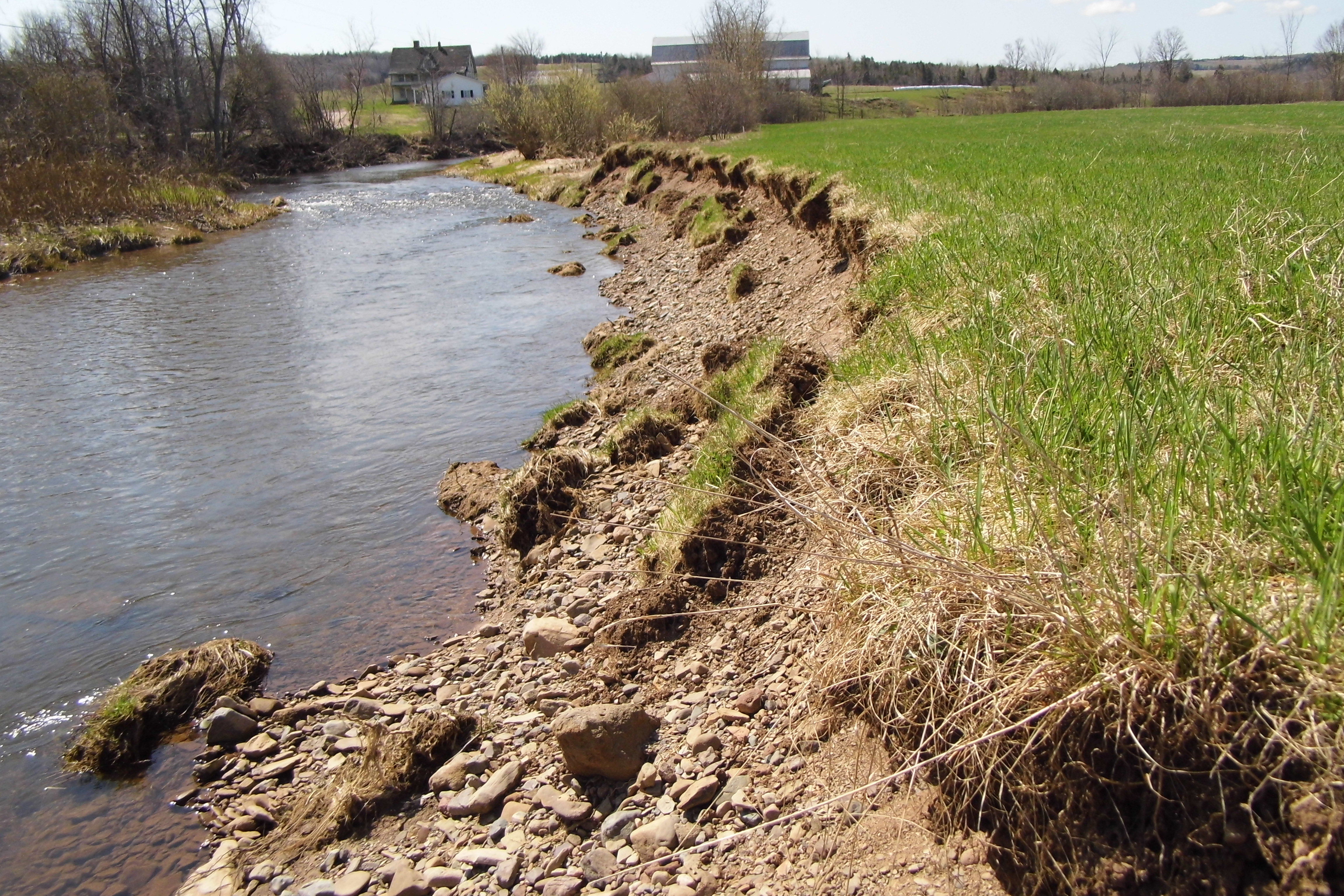
The Kennebecasis Restoration initiative began with a comprehensive habitat assessment of 285.5 km of stream. The results of this assessment highlighted the need to address elevated stream temperatures and degraded riparian zones to improve the health of the watershed. To address concerns over eroding banks and degraded riparian habitat, a restoration project was developed and implemented. Approximately 78% of the Kennebecasis Watershed consists of forested lands, with 19% consisting of agricultural and occupied lands. Agricultural, residential, and other occupied lands directly influence the water quality and habitat conditions of the watershed through cattle grazing, riparian vegetation removal, and agricultural and municipal runoff. Residential areas as well as rural residences, dot the entire length of the Kennebecasis River and its tributaries. Industries such as a potash mine, sawmills, and fish hatcheries are located throughout its reaches. Recreational industries including two golf courses can also be found on the Kennebecasis tributaries. Ward’s Creek is a key tributary of the Kennebecasis and in 2013 the KWRC identified a priority site on this Creek. In 2014, the bank was heavily eroded with a steep slope and minimal vegetation.

For additional climate information, look at the Resources section of this example (below). 
Identifying Actions

The Kennebecasis Watershed Restoration Committee (KWRC) is composed of various provincial and federal departments, local municipalities and local interest groups. Beginning in 1994, the committee has worked on enhancing the general health of the Kennebecasis Watershed, focusing on water quality and fish habitat within the greater Kennebecasis Watershed. Surveys were completed to identify the type and location of major stream habitat problems, and guide in-stream work focused at addressing these problems and improving the aquatic conditions of the watershed. Work has been carried out to decrease erosion, enhance fish habitat, improve the riparian zone habitat and educate the public on environmental issues. The Ward’s Creek Riparian Enhancement initiative is one of the many restoration and enhancement efforts of this organization with the main objective of the project being to improve riparian and aquatic health of the creek through the use of bioengineering and natural-based approaches. Bioengineering/nature-based approaches are relatively new to the Kennebecasis River region, so there was a need to educate landowners and the public about the benefits of this approach. In KWRC’s early years (1994-99), local landowners were not receptive to bio-engineering. As other riparian restoration projects were completed and the conversation continued, landowner relationships grew stronger and in 2014, KWRC completed the first riparian zone and bioengineering enhancement project in the watershed. Through continued engagement and the use of demonstration sites, the KWRC has been able to work with a number of landowners that now recognize the many benefits nature-based approaches can provide, from reduced erosion to the restoration of aquatic and riparian habitat.

Implementation

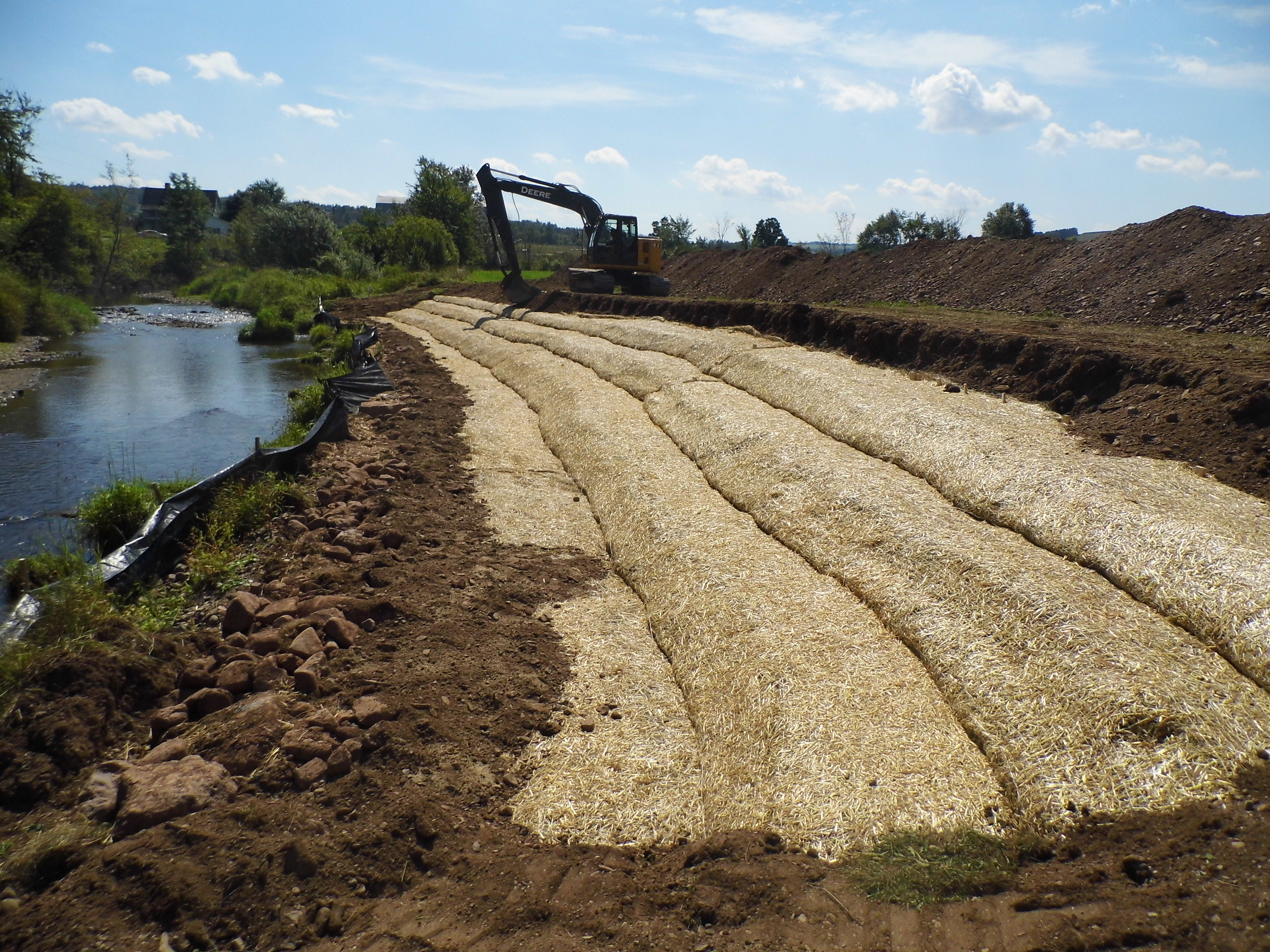
After securing appropriate permits and regrading the slope, the KWRC installed georolls or erosion control blankets (ECB) to stabilize and secure two heavily eroded stream banks. Georolls are a type of mat made from a variety of bio-degradable materials. The KWRC uses coconut fibre georolls that are constructed from discarded coconut husks. The materials were woven together to hold back eroding soils and promote the growth of grasses and vegetation. This natural geotextile layer helps hold seeds, plants, and soil in place. The material was rolled out along the banks and secured it with wooden anchors. Native seedlings, trees, and shrubs are then planted into the georoll to help anchor sediments along the bank and to restore the riparian zone. In total, for this site the KWRC enhanced 530 linear meters of stream and stabilized 72m of eroding stream banks. The eroding banks were back sloped to a 3:1 slope. This work reduces the transfer of sediments, nutrients, and other unwanted pathogens into the river. The slope also enhances flood plain connection and capacity while also improving site sustainability. Further details of the installation process, the tools used, as well as before and after pictures of the restored habitat are available in the video linked below

  1. KWRC GeoRoll Installation: 

GeoRoll Installation

Image of a sustainable urban rainwater management project in the City of Vancouver. The schematic includes incorporation of greenscaping as a way of not only beautifying the streetscape, but also to provide functional purposes such as rainwater management and small areas of habitat refugia. The image shows the integration of sustainable design with climate adaptation actions. Specific foci are on the inclusion of more city street trees, native plants, areas for pollinators, rain gardens, and the creation of common spaces for gathering.

Outcomes and Monitoring Progress

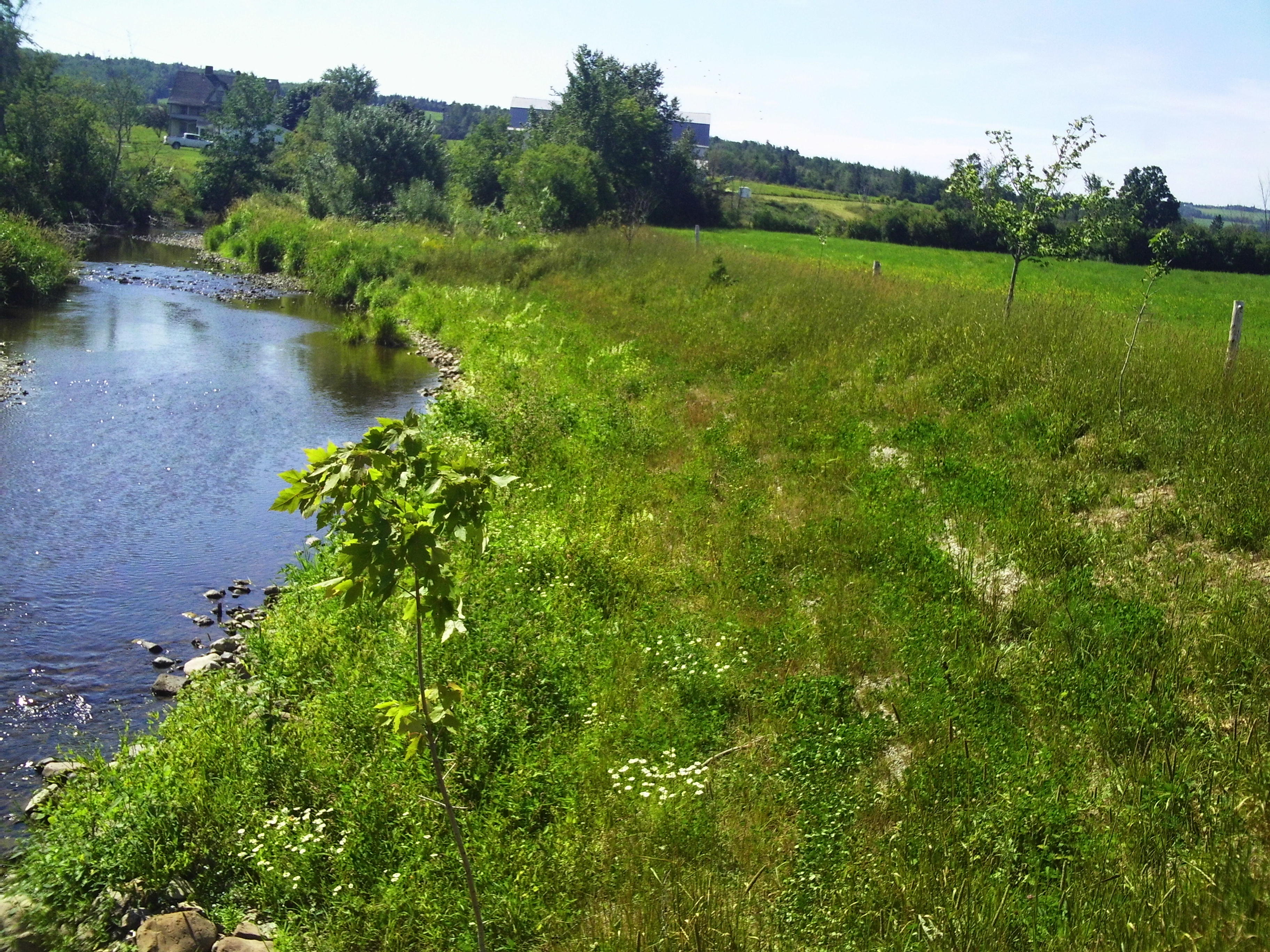
Since the completion of this project, Ward’s Creek has become a demonstration site for bioengineering in the watershed. Since 2014, this site has been flooded many times and has helped provide a wider area for flood waters to spread, alleviating pressure on downstream landowners. This work has also provided KWRC with opportunities to continually engage and educate the public about the unique benefits of nature-based adaptation approaches. The KWRC plans to continue their work improving riparian habitats and building relationships with the public and continuing to engage communities across the Kennebecasis River Watershed. KWRC has two key pieces of advice for others looking to advance this work:

  • Communicate openly and effectively with landowners about the value of bioengineering as a tool to both mitigate flooding and improve the ecological health of the land and water.
  • Use case studies and successful demonstration projects to illustrate how projects will function and assist landowners over time.

This site now provides KWRC’s best example of a bioengineering site and has hosted over 150 people on site tours. KWRC would like to emphasize that this project would not have been successful without the approval from the landowner, John McGibbon.

Before Riparian Enhancement

Image of a sustainable urban rainwater management project in the City of Vancouver. The schematic includes incorporation of greenscaping as a way of not only beautifying the streetscape, but also to provide functional purposes such as rainwater management and small areas of habitat refugia. The image shows the integration of sustainable design with climate adaptation actions. Specific foci are on the inclusion of more city street trees, native plants, areas for pollinators, rain gardens, and the creation of common spaces for gathering.

After Riparian Enhancement and Restoration

Image of a sustainable urban rainwater management project in the City of Vancouver. The schematic includes incorporation of greenscaping as a way of not only beautifying the streetscape, but also to provide functional purposes such as rainwater management and small areas of habitat refugia. The image shows the integration of sustainable design with climate adaptation actions. Specific foci are on the inclusion of more city street trees, native plants, areas for pollinators, rain gardens, and the creation of common spaces for gathering.

Next Steps

The KWRC organization has expanded to complete more restoration projects, water monitoring activities, and education and outreach events within local communities. Through their work, they have demonstrated their passion for improving the habitat and water quality within the Kennebecasis watershed. The KWRC is committed to continuing work with cooperative landowners and partners who are seeking to improve the health of the waterway and they continue to monitor historical sites when resources exist. They commit to a three year plan at each project site in which they complete. Since their beginning in 1994 they have undertaken more than 50 habitat enhancement and restoration sites and since the first nature-based installation in 2014 they have been able to complete similar work on 10 other sites. The KWRC plans to monitor this habitat and continue their work improving other riparian habitats while building strong relationships with communities and landowners across the Kennebecasis River Watershed. Community involvement and stewardship are essential components to their projects that will help to ensure the sustainability of the watershed for years to come.

Resources

Link to Full Case Study:

Additional Resources:


Using climate change projections enables better adaptation decisions, as it allows you to better understand how the climate may change.  To learn how to choose, access, and understand climate data, visit ClimateData.ca’s Learning Zone 

For more information on variables that may be useful in work related to watershed management, visit ClimateData.ca and click “Explore by Variable”. Here you will find pertinent future climate projections related to watershed management including: