Understanding and Assessing Impacts
Prior to the competition, in 2016 the Borough undertook a series of environmental, social, and spatial site studies to identify opportunities to improve environmental quality and enhance human health and wellbeing by restoring ecological conditions on underutilized land. At the time, a central focus of the municipality was on improving connectivity between fragmented ecosystems using corridors and buffer zones. They completed various mapping exercises documenting forests, wetlands, rivers, and other ecosystems to understand their spatial relationships and to identify connectivity opportunities across scales of terrestrial, hydrological and aerial systems. The Borough also held a comprehensive engagement process to align biodiversity and social objectives, which helped to situate the corridor project within broader city-wide initiatives, and formed the basis of the programming requirements for the design competition.
Following the competition, the project partners conducted three primary site analyses:
- A systematic mapping of soil conditions and stormwater infrastructure across the site;
- A comprehensive assessment and inventory of the local fauna and connectivity, including the relation to human activity and accessibility; and
- The Biodiversity Report (Annex A1 to the Plan Directeur d’Aménagement), which synthesized data from previous surveys, official publications, and fieldwork, and provided the scientific foundation for mapping and analysis.
Additional assessments of the paved surfaces, materiality, and canopy distribution were conducted, and revealed elevated heat island exposure, affecting both ecological quality and human thermal comfort. This information presented key vulnerabilities that would eventually guide design direction:
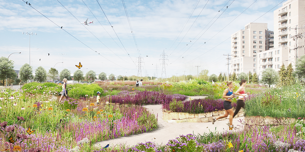
- Gaps in ecological connectivity, including fragmented and uneven vegetation distribution that restricts ground and aerial fauna movement, disconnected water bodies that limit aquatic and amphibian habitats, and intensive human activity and road infrastructure that pose significant barriers to terrestrial wildlife mobility.
- Flood-prone areas / areas of high flood risk, resulting from limited permeable surfaces and insufficient sustainable drainage systems (SuDS), such as stormwater retention areas, rain gardens, and infiltration zones.
- Urban heat island exposure, driven by extensive paved surfaces and a lack of tree canopy and vegetation cover.
Use of Climate Information in Decision-Making
The vision for the Saint-Laurent Biodiversity Corridor was developed using a multidisciplinary and multidimensional approach, considering both the neighbourhood and the regional scale, and focused on coexistence between human activity and ecological systems within the heavily developed context of Saint-Laurent. While no dedicated climate modelling was undertaken, principles of climate resilience and adaptability were embedded into the long-term framework, and design interventions were informed by city-wide objectives and projections, such as those within the Climate change adaptation plan for the Montréal Urban Agglomeration 2015-2020. The design approach also relied heavily on established best practices and professional benchmarks, such as standard shade coverage targets to determine whether environmental conditions were sufficient.
While climate adaptation was not the original focus, strategies that improve livability such as increasing canopy cover, enhancing green infrastructure, and mitigating urban heat islands, aligned ecological and community resilience goals. Managing climate and microclimate conditions was a central focus of the master plan, prioritizing an increase in tree canopy cover and establishing a secondary network of street-level vegetation to reinforce ecological networks, enhance livability, and reduce urban heat. Interventions also incorporate permeable paving and integrated stormwater management strategies along main streets and in areas identified as underperforming to contribute to greater climate resilience. Additional vegetated retention areas, rain gardens, and infiltration zones are proposed to mitigate stormwater and reduce flood risks, based on future projections that indicate an increase in frequency and intensity of storm events. Although the initial strategies were informed by qualitative and spatial analysis, the implementation framework is long-term and intentionally adaptable, enabling strategies to be refined and expanded as updated quantitative climate data evolves and becomes more accessible in practice.