Understanding and Assessing Impacts
This assessment adopted a habitat approach, based on the insights gained throughout community engagement. This risk assessment drew from the results of recent climate change vulnerability and risk assessments, making sure risk information is captured and presented in ways that can be easily used for the development of risk products and communication materials.
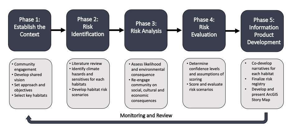
The figure below illustrates the approach to this project and how it combined Indigenous knowledge with western science information in conducting the risk assessment. The first step of the assessment approach was to assemble information on the climate sensitivities of specific habitats and species of particular importance to the communities. The second step was to prepare an overview of past and projected changes in climate conditions to which the identified habitats and species are particularly sensitive. The assembled information on climate-related sensitivities, and experienced and projected climate change impacts, was then used to establish a provisional risk registry and assess the degree of risk as it relates to environmental consequences of climate impacts. Risk was defined as the potential for consequences where something of value is at stake and where the outcome is uncertain. Historic (1981-2010) and projected future (2050s) trends in a number of climate variables under the RCP 8.5 emissions scenario were used to inform the probability of each risk scenario. The Climate Change Hazards Information Portal (CCHIP) was used to provide climate data for most risk scenarios. The Climate Atlas of Canada was used to validate and further inform select likelihood scores. Certain climate hazards such as wind, wildfire, changing lake levels and ice cover projections were derived from external sources, as this climate data is not included in CCHIP or the Climate Atlas. The following sources were used to inform likelihood scoring for these parameters:
- Wind – Environment and Climate Change Canada (ECCC)
- Wildfire – Forest Change Data Catalogue (NRCan)
- Lake Levels – Environment and Climate Change Canada (ECCC)
- Ice Cover – National Oceanic and Atmospheric Administration (NOAA)/Great Lakes Environmental Research Laboratory (GLERL)

