LID Case Studies: Clairfields, Westminster Woods and Pine Ridge Subdivisions (Guelph, ON)

This case study reviews an example of the implementation of “greenways” (a form of low impact development [LID]) in three subdivisions located in the south end of Guelph, Ontario, with the aim to overcome issues regarding stormwater management, maximize onsite groundwater recharge, and ensure that the infiltrated stormwater does not negatively impact groundwater quality. The Clairfields, Westminster Woods and Pine Ridge subdivisions (hereafter referred to as the “South End subdivisions”) are located in the southern portion of Guelph, occupying lands immediately to the east and west of Gordon Street (bounded between Arkell Road and Clair Rd.). A unique feature of the South End subdivisions is their use of large infiltration practices, called “greenways,” as the primary means of handling stormwater on-site. This case study reviews the utilization of “greenways” and use of on-site infiltration practices driven by ideal soil conditions and inability to connect to municipal storm sewer system. Greenways provide recreational amenity for residents through trail network, parks and playgrounds.

Understanding and Assessing Impacts

Prior to development, the predominant land use was agricultural. The topography of the site was relatively flat, with a small kettle lake located in the area that would become Westminster Woods East. There were no existing natural or man-made connections to Hanlon Creek or its tributaries – all rainfall would infiltrate onsite. Only rainfall events greater than the regional storm would generate surface runoff that would leave the site. The total size of the South End subdivisions is quite large (approx. 250 Hectares) and has developed through the course of multiple phases. The developments are mixed use, comprising single detached housing, multi-residential townhouses and low-rise buildings, as well as schools and commercial shopping areas. The subdivisions are well integrated within the community, and include an extensive recreational walking trail system and public transit routes that travel through the subdivision. The site also includes a number of green demonstration homes, including Canada’s first LEED Platinum home and a water efficient Blue Built Home.

While climate impacts and risks were not the driving motivation behind the use of infiltration practices at the South End subdivisions, increasing the use of greenways, bioretention and other innovative stormwater management techniques enhances the regions climate resilience in dealing with the impacts of increasing precipitation and extreme storm events.

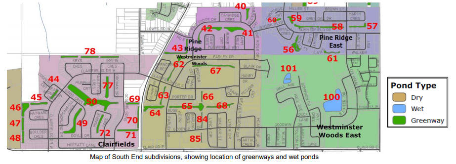
Clairfields, Westminster Woods and Pine Ridge Subdivisions: Map showing location of greenways and wetponds

Image of a sustainable urban rainwater management project in the City of Vancouver. The schematic includes incorporation of greenscaping as a way of not only beautifying the streetscape, but also to provide functional purposes such as rainwater management and small areas of habitat refugia. The image shows the integration of sustainable design with climate adaptation actions. Specific foci are on the inclusion of more city street trees, native plants, areas for pollinators, rain gardens, and the creation of common spaces for gathering.

Identifying Actions

Prior to initiating the design and construction of the South End subdivisions, extensive planning and site investigation work was conducted. Preliminary studies on the development of the site started as early as 1984, although much of the work took place throughout the 1990’s. These studies found that the site was ideal for infiltrating stormwater runoff, as virtually no surface runoff was observed at the site pre-development. As large-scale infiltration practices were uncommon during this period, there were concerns among the parties involved (Ontario Ministry of Environment, Ontario Ministry of Natural Resources, Grand River Conservation Authority and the City of Guelph) as to the long-term performance of infiltration practices. To address these concerns a smaller parcel of the available lands, Pine Ridge West, was selected to be developed first as a pilot project. Monitoring during and following construction found this development to be a success, which provided assurance to the stakeholders to continue. Another concern expressed by one of the stakeholders – the City of Guelph – during the planning stages was the maintenance of the stormwater management practices. In the case of Westminster Woods, this concern was addressed in part through the creation of a condominium corporation for the subdivision, which has the legal name Westminister Woods Ltd. The corporation is responsible for maintaining all of the common elements, including performing general landscape maintenance (trash removal and mowing) of the stormwater management practices. By working collaboratively, the developers, consultants and stakeholders were able to address the issues and concerns that arose, facilitating a streamlined planning and review process for the subdivisions.

Implementation

The South End subdivisions are unique in that they employ the principles of LID, but at greater scale than is considered typical for this type of best practice. Greenway System: Throughout much of the subdivisions, stormwater runoff is collected from the roadways using typical catch basins and piping. However, rather than discharging to a stormwater management pond, the runoff is directed to large-scale bioretention facilities, called “greenways.” The greenways have 3:1 side slopes, and the bottoms are essentially flat to distribute runoff to the largest possible ground surface and maximize infiltration. The greenways are wide vegetated channels containing a variety of plant species. A low maintenance dry-mesic meadow seed mixture was used throughout much of the greenway system (e.g., 25% Canada blue grass, 25% Creeping red fescue; 25% Perennial ryegrass; 10% red clover; 10% Black-eyed Susan; 5% New England aster).

The bottom layer of the greenways have a 300 mm thick sand layer covered with topsoil. The sand layer is used to prevent fine sediments from accumulating in the native gravel soils. The greenways at Westminster Woods were designed to infiltrate up to a 100 year storm event. The typical drawdown time for rainwater in the greenway is approximately 3 days (depending upon antecedent conditions). To facilitate infiltration during larger rainfall events, infiltration trenches were dug parallel to the greenway (along each side). The greenways also act as a means of conveyance in the event of intense rainfall events. The greenways are slightly sloped towards a central floodway. The central floodway can handle a regional storm rainfall event, using overland flow to convey stormwater to the Hanlon Creek. Prior to discharging stormwater to the greenways, it is pre-treated by means of oil & grit separator units. This project also utilized existing site features such as a traditional stormwater management pond, as in the case of Westminster Woods East.

Clairfields, Westminster Woods and Pine Ridge Subdivisions

Schematic of greenway system, showing flat greenway base and infiltration trenches located on side-slopes.

Image of a sustainable urban rainwater management project in the City of Vancouver. The schematic includes incorporation of greenscaping as a way of not only beautifying the streetscape, but also to provide functional purposes such as rainwater management and small areas of habitat refugia. The image shows the integration of sustainable design with climate adaptation actions. Specific foci are on the inclusion of more city street trees, native plants, areas for pollinators, rain gardens, and the creation of common spaces for gathering.

Outcomes and Monitoring Progress

As part of ensuring the safety of Guelph’s groundwater supply, infiltrating high quality stormwater was one of the major goals of the development. Collection of samples from monitoring wells spread throughout the site revealed that for many of the water quality parameters, this target was achieved. Although higher than the Ontario Drinking Water Standard (ODWS) limit, nitrate concentrations throughout the shallow aquifer system showed a decreasing trend over the years, which was attributed to conversion of the land use from agricultural to residential. Some other water quality parameters, like dissolved organic carbon, hardness, iron, and manganese were higher than the maximum permitted concentrations, but these concentrations were present prior to development. Surface water and groundwater monitoring also revealed the impact of the groundwater table on the performance of the infiltration practices. The majority of the greenway system has had no issues with slow infiltration rates or ponding. However, one section of the greenway did experience ponding due to the presence of an elevated groundwater table in the area, thus the original meadow grasses and plantings have been replaced by more wetland species, including cattails. These observations stress the importance of conducting geotechnical studies in the planning stages to ensure that LID practices are placed in the appropriate location ensuring a minimum 1 meter distance between the bottom of the LID underdrain and the water table.

The barriers encountered with this project included:

  • Extensive pre-development groundwater and surface water monitoring required to support proposed greenway system
  • Concerns among stakeholders regarding long term performance of infiltration practices, particularly cold weather performance
  • Some encroachment of greenway and disruption to rear yard infiltration trenches by residents following construction.

The following approaches were used to address these barriers:

  • Data provided by multi-year groundwater and surface water studies demonstrated that largescale infiltration would work
  • Stakeholders undertook a phased approach, first subdivision used as a pilot to demonstrate effectiveness of greenway system

A main lesson learned is that better education is required to inform residents of the location and function of LID practices on (or near) their property.

Next Steps

To ensure the continued successful operation of the greenway system, ongoing monitoring and maintenance will be required. One of the developers in the project provided a list of maintenance activities to the City. These maintenance activities are applicable to most LID practices, and are highly recommended:

  • Monitor the conditions of LID practice(s) [the greenway system], paying close attention to areas where decreased infiltration rates are observed.
  • Monitor levels of sediment accumulation in LID practice(s) and pre-treatment facilities (OGS units, forebays, etc.) and schedule cleanouts of these facilities as required.
  • Perform regular landscape maintenance activities, and instruct maintenance crews to control weed proliferation and replace dead/dying plants and trees.

Resources

Link to Full Case Study

Additional Resources:

Using climate change projections enables better adaptation decisions, as it allows you to better understand how the climate may change. To learn how to choose, access, and understand climate data, visit ClimateData.ca’s Learning Zone.
For more information on variables that may be useful in work related to stormwater and wastewater management, visit ClimateData.ca and click “Explore by Variable”. Here you will find pertinent future climate projections related to:

  1. Historic and climate change scaled IDF data
  2. Total precipitation
  3. Maximum 1-day total precipitation
  4. Wet days (>1mm, >10mm, >20mm)