Intertidal Reefs at Souris, Prince Edward Island

The Town of Souris, Prince Edward Island (PEI), is a coastal community that is dependent on tourism and fishing. Similar to PEI’s other coastal communities, Souris has been forced to deal with the storms and wave action that have been eroding its sandstone shoreline and threatening its infrastructure. The causeway into the town is a vital conduit for the local economy and is a popular beach for tourists. Climate change with the associated rising sea levels, reduced ice cover, and changing storm patterns threaten to exacerbate this problem. In order to improve protection of the PEI portion of the Trans-Canada Highway (Hwy 2), PEI Transportation Infrastructure and Energy (PEI-TIE) worked with Coldwater Consulting Ltd. to develop and construct a two-part shore protection scheme that combined hard protection for the highway infrastructure with beach restoration works that would improve the resilience of the beach and dune system: 1. A timber/piled seawall was constructed parallel to Highway 2. This seawall allows for protection of the highway, while also extending the existing promenade along the top of the seawall. The wall was set back from the beach face to allow adequate space for beach restoration. 2. Dune restoration and shoreline stabilization works were undertaken to restore and strengthen the existing sand beach – dune system. The beach restoration works included the construction of two inter-tidal reefs. This is the first time that inter-tidal reefs have been used on the Island. An example of ‘building with nature’, the sandstone reef structures provide two primary functions: wave attenuation, dampening the effects of storm waves on the beach area and highway infrastructure; and, creating an area of calmer water on the landward side of the reefs where sand that is moving along the shore area will slow down and deposit and, over time, accumulate and cause the beach to grow / extend offshore towards the reefs. The result is increased beach width and protection of the dunes and coastal / highway infrastructure.

Read the Full Story

Understanding and Assessing Impacts

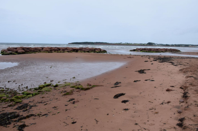
Shoreline erosion and relative sea level rise are increasing the risk of flooding and storm damage to Highway 2 as it approaches the Town of Souris in PEI. Climate change with the associated rising sea levels, reduced ice cover and changing storm patterns threaten to exacerbate this problem. The risk of flooding and temporary closure of Highway 2 at this location will increase over time. These considerations, along with the erosion and inundation observed during the 2016 storms, led to a decision by the Province to protect the highway. With increasing concern over the effects of climate change, there is an increased interest in developing durable, resilient shore protection works. Various approaches have been used to protect the causeway infrastructure including Gabion baskets, armourstone, and a timber crib and steel pile wall. These efforts have supported local economic growth, such as the expansion of the Souris Beach Gateway Park, new commercial outlets and a playground. Traditional armouring approaches, however, require periodic and sometimes costly maintenance over the long term. In some situations, this armouring approach can also accelerate erosion and deplete a beach of valuable sand. With that in mind, a project to implement a naturalized infrastructure installation in PEI was initiated in 2018. Two intertidal reefs were designed by the provincial government to increase the resilience of the beach and dune system while protecting the causeway and park infrastructure

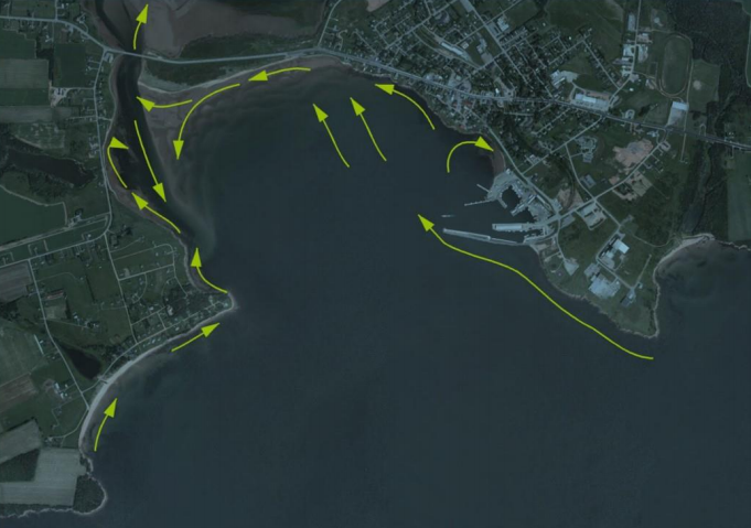
Sediment pathways in Colville Bay

Image of a sustainable urban rainwater management project in the City of Vancouver. The schematic includes incorporation of greenscaping as a way of not only beautifying the streetscape, but also to provide functional purposes such as rainwater management and small areas of habitat refugia. The image shows the integration of sustainable design with climate adaptation actions. Specific foci are on the inclusion of more city street trees, native plants, areas for pollinators, rain gardens, and the creation of common spaces for gathering.

Identifying Actions

Given the increasing concerns of climate change, there has been a continued effort to protect this area of the coast through various means, beginning with an armour-stone revetment in December 2001 and further shore protection works in 2012 wherein a timber crib / steel pile sea wall was built, known locally as a Langley wall. The winter storm that struck in January 2016 raised concerns about the vulnerability of the highway to damage in subsequent storm events.

The province worked closely with a local contractor, the town of Souris, as well as the local watershed group, the Souris Wildlife Federation, to study sediment patterns in Colville Bay and come up with the implemented method to reduce coastal erosion that has been threatening the causeway, a critical piece of infrastructure. Too often, coastal protection works involve the armouring of a shoreline to protect land and infrastructure, while often destroying the beach. From both ecological and societal perspectives, the sandstone bluffs and sandy beaches of Prince Edward Island are too important to allow them to be lost beneath concrete and imported stone. The development of innovative protection works that can stabilize and build beaches and enhance dunes is an essential step in the Province’s development of truly resilient and sustainable measures to address coastal hazards and climate change. For Coldwater Consulting and PEI TIE, the emphasis of coastal protection works has always been on only building shore protection when it is economically and logistically imperative, and on integrating beach and dune protection within any such works. The design for the Souris reefs is based on numerical modelling of waves and sediment transport along Souris Beach in conjunction with geomorphic assessments of coastal processes. The Town of Souris and the Souris Area Branch of the PEI Wildlife Federation were consulted extensively as part of the design process, through both public sessions and inter-agency consultations.

Implementation

Analysis of beach profiles at several locations from the end of the existing seawall to 200m west show that the beach lost between 4.5 to 6.0 m2 of cross-sectional area between 2010 and 2016. The remaining dune (as of January 23rd) had a crest elevation of between 2.1 and 2.5m with some spots as low as 2.1m. With the very small volume of remaining sand, a single storm would now be capable of breaching the dunes, allowing wave action to reach the edge of the highway. Given that the highway is lying at approximately the 25-year return period still water level, this placed the highway at considerable risk of storm damage.

In order to determine the impacts of post-project condition on shoreline, both pre- and post-project conditions was analyzed using the US Army Corps of Engineers GENESIS model (GENEralized Model for SImulating Shoreline Change). This model computes changes to beach plan-shape in response to sediment supply, waves, and the presence of sediment control structures. Review and evaluation of the design alternatives, including the results from the GENESIS modeling resulted in several observations that indicate intertidal sandstone reef structures were seen to provide the best solution in terms of shore protection, beach preservation and touristic/aesthetic considerations.The reefs, which were installed in March 2018 as an experimental pilot project at a cost of $115,000. The reefs act as protective barriers against wave action upon the shore and, furthermore, are helping the beach to return as a result of wave attenuation and subsequent deposition of sediment behind the reefs. The reefs also provide a natural environment for benthic flora to grow. Finally, the reefs are constructed using PE sandstone, which is not only less expensive than traditional imported granite, but also blends in perfectly with the surrounding sediment as it slowly degrades over time.

Outcomes and Monitoring Progress

Two sandstone reefs installed by the Prince Edward Island government along the Souris causeway are having their intended effect. Subsequent monitoring has shown that the reefs have generally performed as anticipated with a small tombolo beach formation growing in the lee of the two structures. This has led to increased dry beach area that has, in turn, led to growth and vegetation of the landward dunes. From a tourism/recreation perspective, the changes to the beach have met with positive feedback from beachgoers and the Souris community. Post-construction monitoring is being conducted using a combination of site visits, RTK-GPS surveys and drone overflights. To date there have been minimal downdrift changes to the Souris beach and benthic growth in and around the reef structures has been encouraging. While the structure is viewed as an adaptive management strategy – allowing for structural modifications to the reefs as needed to tweak the beach response – to date, no modifications have been required. Beach surveys are planned to continue for the next few years to monitor performance and to inform any adaptive measures that may be required.

Intertidal Reefs at Souris, PEI

Intertidal reefs at low tide August 2018

Image of a sustainable urban rainwater management project in the City of Vancouver. The schematic includes incorporation of greenscaping as a way of not only beautifying the streetscape, but also to provide functional purposes such as rainwater management and small areas of habitat refugia. The image shows the integration of sustainable design with climate adaptation actions. Specific foci are on the inclusion of more city street trees, native plants, areas for pollinators, rain gardens, and the creation of common spaces for gathering.

Next Steps

Given the success of the reefs, the province is considering similar projects in other areas of the Island. The province and Coldwater Consulting also intend to apply for an environmental achievement award through the Association of Professional Engineers of Prince Edward Island for the project.

The shoreline restoration and stabilization works at Souris illustrate the potential for ‘working with nature’ when protecting critical infrastructure against the coastal effects of climate change. Through monitoring and adaptive management, it is hoped that this project will form an important turning point for the development of coastal protection works that preserve and enhance the shoreline while also protecting critical infrastructure.

Resources