Climate Change Information Products for Indigenous Communities in Bruce, Grey and Huron Counties of Southern Ontario

Over the course of two years (2020-2022), the Climate Risk Institute (CRI), thanks to funding to the Council of the Great Lakes Region (CGLR) from Bruce Power (BP), was contracted by CGLR to engage Indigenous communities in Grey, Bruce, and Huron counties to produce knowledge and information products that address opportunities and risks related to climate change and specific environmental, cultural and socioeconomic values and activities. The natural environment of traditional Indigenous lands in these three counties plays an important role in providing benefits for cultural, spiritual and economic well-being. This project was part of a multi-year study to understand the state of climate change science in the Great Lakes and the impacts of the changing climate on various sectors and ecosystems in the region. Over the course of the project, literature on climate change vulnerabilities, risks and opportunities was assembled and reviewed to develop risk scenarios and capture current and projected risks. The project resulted in three different information products that presented the results of the risk assessment and the impacts/opportunities of a changing climate to the Indigenous communities in the region. These products were:

  1. Summary Risk Registry
  2. Risk Narratives Report
  3. ArcGIS Story Map

Understanding and Assessing Impacts

This assessment adopted a habitat approach, based on the insights gained throughout community engagement. This risk assessment drew from the results of recent climate change vulnerability and risk assessments, making sure risk information is captured and presented in ways that can be easily used for the development of risk products and communication materials.

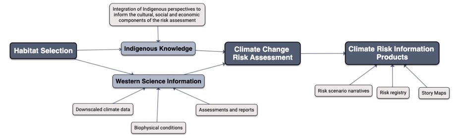
The figure below illustrates the approach to this project and how it combined Indigenous knowledge with western science information in conducting the risk assessment. The first step of the assessment approach was to assemble information on the climate sensitivities of specific habitats and species of particular importance to the communities. The second step was to prepare an overview of past and projected changes in climate conditions to which the identified habitats and species are particularly sensitive. The assembled information on climate-related sensitivities, and experienced and projected climate change impacts, was then used to establish a provisional risk registry and assess the degree of risk as it relates to environmental consequences of climate impacts. Risk was defined as the potential for consequences where something of value is at stake and where the outcome is uncertain. Historic (1981-2010) and projected future (2050s) trends in a number of climate variables under the RCP 8.5 emissions scenario were used to inform the probability of each risk scenario. The Climate Change Hazards Information Portal (CCHIP) was used to provide climate data for most risk scenarios. The Climate Atlas of Canada was used to validate and further inform select likelihood scores. Certain climate hazards such as wind, wildfire, changing lake levels and ice cover projections were derived from external sources, as this climate data is not included in CCHIP or the Climate Atlas. The following sources were used to inform likelihood scoring for these parameters:

  • Wind – Environment and Climate Change Canada (ECCC)
  • Wildfire – Forest Change Data Catalogue (NRCan)
  • Lake Levels – Environment and Climate Change Canada (ECCC)
  • Ice Cover – National Oceanic and Atmospheric Administration (NOAA)/Great Lakes Environmental Research Laboratory (GLERL)

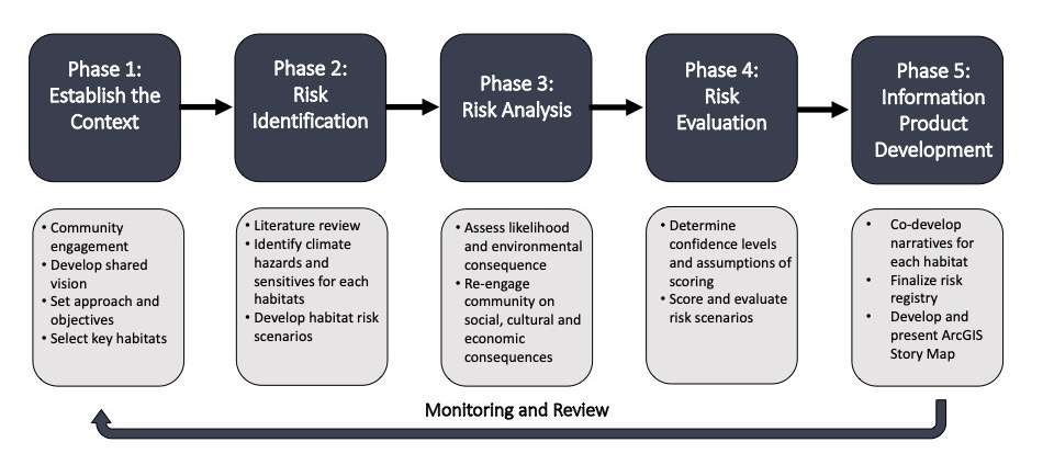
Risk Assessment Approach

Image of a sustainable urban rainwater management project in the City of Vancouver. The schematic includes incorporation of greenscaping as a way of not only beautifying the streetscape, but also to provide functional purposes such as rainwater management and small areas of habitat refugia. The image shows the integration of sustainable design with climate adaptation actions. Specific foci are on the inclusion of more city street trees, native plants, areas for pollinators, rain gardens, and the creation of common spaces for gathering.

Identifying Actions

Consultations with the three Indigenous communities were conducted early in the process to establish a common understanding of the status of climate risk needs and interests. The project team presented existing climate change risk assessment frameworks, including the Climate Change Vulnerability Assessment Framework developed by the Great Lakes Indian Fish and Wildlife Commission (GLIFWC) and examples of several climate information products. From here, a habitat-based approach was confirmed by the Community, referencing key processes from the GLIFWC framework. Follow-up discussions with community members helped to identify key habitats and species of particular interest to prioritize for the assessment. During these discussions the project team was able to determine the participation and involvement levels of each community in reviewing available literature, compiling the risk registry and developing risk information products. Community representatives also indicated the types of information products of greatest potential interest and use. These include vulnerability indices for key species and habitats as well as ArcGIS-based story maps. To ensure the completion of the assessment and associated climate information products, three habitats were selected for this project:

  • Great Lakes,
  • Coniferous and mixed forests,
  • Alvars and cliffs.

This selection was based on two main criteria, which were 1) inclusion of terrestrial, aquatic, and unique habitats and 2) inclusion of species of significance to the community. Social, cultural, and economic consequences associated with each risk scenario were assessed using a qualitative approach. Community insight was integral for informing this part of the assessment, as the literature does not provide the level of detail or community-specific considerations required for the assessment of these consequence areas.

Project Phases and Outcomes

Image of a sustainable urban rainwater management project in the City of Vancouver. The schematic includes incorporation of greenscaping as a way of not only beautifying the streetscape, but also to provide functional purposes such as rainwater management and small areas of habitat refugia. The image shows the integration of sustainable design with climate adaptation actions. Specific foci are on the inclusion of more city street trees, native plants, areas for pollinators, rain gardens, and the creation of common spaces for gathering.

Implementation

The project team worked with three Indigenous communities in Grey, Bruce and Huron Counties to produce knowledge and information products that address opportunities and risks related to climate change and specific environmental, cultural and socioeconomic values and activities of importance to the communities. The communities were the Saugeen Ojibway Nation (SON), the Historic Saugeen Métis (HSM), and Métis Nation of Ontario (MNO). Consultations with partners from all three communities played a crucial role in the project and helped establish a common understanding of key needs and interests. Over the course of our research work the project team assembled and reviewed information on climate sensitivities of specific habitats and species of particular importance to the communities and prepared an overview of past and projected changes in climate conditions to which the identified habitats and species are particularly sensitive. The assembled information on climate-related sensitivities, and experienced and projected climate change impacts, was then used to establish a risk registry and assess the degree of risk as it relates to environmental consequences of climate impacts. Social, cultural, and economic consequences associated with each risk scenario were informed by conversations and consultations with communities’ members and assessed using a qualitative approach. These discussions also helped identify the types of risk information products that would be of greatest interest and use to the communities, such as ArcGIS-based story maps.

Outcomes and Monitoring Progress

The results of the project were information products that summarized the current and future environmental, cultural, and socioeconomic impacts of the changing climate on the three habitat types assessed. These products were:

  1. Summary Risk Register: Results from a detailed risk assessment process were summarized in a summary risk registry. This document gives an overview of the risk assessment process, key habitats, habitat components, climate drivers and impacts, current and future risk scores and confidence levels for each habitat that was assessed. Accurately scoring the risk for rare habitats such as Alvars and Cliffs was a challenging component of this process as this habitat is relatively understudied and limited literature existed on the impacts that a changing climate could have.
  2. Climate Risk Narratives Report: A risk narratives report was developed to provide more methodological and qualitative information about the assessment to complement the risk registry. For each critical habitat that was assessed the report outlines current and projected future climate trends, assessed hazards and indices, vulnerability considerations, environmental consequences and potential opportunities. Additionally, it provides details on community-specific social, cultural and economic impacts derived from multiple rounds of consultations and engagement.
  3. ArcGIS-based Story Maps: Research and engagement work with SON, HSM and MNO communities resulted in the development of three story maps that explore climate trends, impacts and opportunities for key terrestrial, aquatic and rare habitats on traditional Indigenous and Métis lands in Grey, Bruce and Huron counties. Information on expected changes in climate, species and habitat vulnerability, environmental impacts, community consequences and potential opportunities is supported by videos, photos and graphs as well as interactive elements such as web maps.

Three webinars were held in March 2022 with partners and representatives from each Indigenous community to present the information products and discuss next steps such as plans to share the products as well as maintain and update them over time.

Next Steps

Observation and monitoring:

  • Build on Story Map to include section on community stories, observations and experiences
  • Risk registry and supporting report could be used to support land-use planning, resource management, and climate adaptation planning

Community outreach and education:

  • Products will be used educate community members on climate change risks and adaptation, and support existing community initiatives

Consultation tool/external use:

  • Build on community impacts and observations into Story Map and/or risk registry
  • Use as a consultation tool to streamline climate change related inquiries (e.g., municipal requests for climate change adaptation planning)

Sharing of products:

  • Risk registry and narratives report can be shared with community staff and members
  • Sharing on Bruce Power, Council of Great Lakes Region and CRI webpages and social media
  • Sharing on Indigenous community webpages and/or social media

Product maintenance and updating:

  • Community staff participated in an ArcGIS Story Map training session with CRI with the objective of enabling staff to add new information and update products overtime

Resources