Addressing increasing flood risk in Surrey, BC

In response to sea level rise and more frequent and severe precipitation, causing flooding in the coastal area occupied by the City of Surrey, BC, the City began developing its Coastal Flood Adaptation Strategy (CFAS) in 2016, with funding from FCM’s Municipalities for Climate Innovation Program (MCIP). Surrey’s coastal floodplain spans 20 percent of its land base. Flooding in this area would directly impact more than 2,500 people in residential neighbourhoods and in the Semiahmoo First Nation. The environmental impacts include rising groundwater levels, saltwater intrusion, coastal squeeze and increased shoreline erosion. Some of the most vulnerable sectors in the region are agriculture, transportation and infrastructure. Parks, recreational areas and critical wildlife habitat are also at risk. Over the three-year planning process, a range of adaptation approaches were evaluated and refined using a values-based approach and meaningfully engaging participants in project decision-making, resulting in longer-term strategic directions for each of the CFAS Planning Areas, as well as 46 program, policy, and Planning Area-Specific actions that can be taken over the short, medium and long-term. This community-driven approach helped Surrey secure the largest federal grant the city has ever received—a grant of $76 million through the Disaster Mitigation Adaptation Fund (DMAF). This grant will assist the City of Surrey in implementing 13 projects valued at $187 million, which will advance initial phases of several CFAS Planning Area-Specific actions between 2019 and 2027. The city undertook a separate project to gain an understanding of the specific risks to critical infrastructure assets in the Mud Bay planning area (a subsection of the floodplain most vulnerable to flooding). This localized study, Improving Coastal Flood Adaptation Approaches (ICFAA), was informed by the analysis done while developing the CFAS, and the results fed back into the broader flood adaptation strategy.

Read the Full Story

Understanding and Assessing Impacts

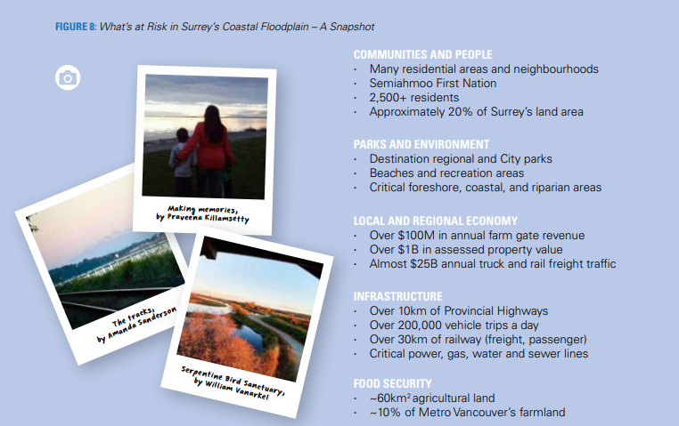
Surrey’s coastal floodplain makes up about 20% of Surrey’s entire land area. This large, low-lying area stretches from Boundary Bay and Mud Bay along the Nicomekl and Serpentine Rivers towards Cloverdale and Newton. The floodplain also includes the Campbell River/Semiahmoo Bay area near White Rock and Semiahmoo First Nation. As a natural floodplain, the area has regularly experienced some coastal flooding over the years from high tides and storm surges, along with river floods which are typically caused by rainstorms and snow melt but can also be influenced by high tides and storm surges. The two principal causes of increased flooding in Surrey’s coastal floodplain are 1. sea level rise and 2. increased magnitude and intensity of rain – both a result of climate change. The current climatic risks within the CFAS planning area include risks to communities and people, local parks and environment, the local and regional economy, and infrastructure.

The City of Surrey’s CFAS is focused on evaluating the impact and effectiveness of potential large-scale adaptation actions that could be applied to the entire floodplain area. Within the Mud Bay area, there are several infrastructure assets in operation that are vulnerable to the effects of climate change. These include transportation, utility, flood control, and marine infrastructure with local, regional, provincial, national, and international significance. In recognition of this, the City of Surrey initiated the ICFAA process, focusing on a subsection of the Surrey floodplain west of 152 Street. This localized study area was selected because of the number of critical infrastructure assets within it, and because it is the area which is most likely to be affected by future flooding events. The ICFAA was structured as a standalone project, with its own reporting, yet was integrated into the CFAS process. Outcomes from the CFAS process fed into the ICFAA process, and then results of the ICFAA analyses helped to support the progression of the CFAS.

What's at Risk in Surrey's Coastal Floodplain

Image of a sustainable urban rainwater management project in the City of Vancouver. The schematic includes incorporation of greenscaping as a way of not only beautifying the streetscape, but also to provide functional purposes such as rainwater management and small areas of habitat refugia. The image shows the integration of sustainable design with climate adaptation actions. Specific foci are on the inclusion of more city street trees, native plants, areas for pollinators, rain gardens, and the creation of common spaces for gathering.

Identifying Actions

The City of Surrey is in the process of developing a comprehensive strategy to address coastal flooding risks in the Mud Bay area. The area has the potential to be affected by coastal flooding (king tides and storm surge), as well as riverine flooding from the Serpentine and Nicomekl Rivers. The risk of flooding by either mechanism is anticipated to greatly increase with climate change and sea level rise. In support of Phase 1 of the CFAS process, the City engaged Associated Engineering (AE) to plan and deliver a workshop targeted at infrastructure owners and emergency service providers. This workshop was held on March 28, 2017, and was attended by 66 participants representing 28 organizations. The workshop used the Engineers Canada Public Infrastructure Engineering Vulnerability Committee (PIEVC) High Level Screening Tool to assess the infrastructure in the Mud bay study area. The use of the procedure allows for a systematic process of assessing flood vulnerability of the various infrastructure types affected by flooding in the lowlands. The workshop focused on identifying vulnerabilities to, and interactions between, transportation infrastructure (rail, roads, trails, and runways), utilities (power, gas, sanitary sewers and lift stations), and flood control / marine infrastructure (marinas, private docks, drainage pump stations, sea dams, and dykes) and assessing the consequences of the impacts from flooding. Using the PIEVC process, risk scores were developed for each interaction between infrastructure component and flood scenario. To determine the risk score (R) for each interaction, a probability score (P) was established for each flood scenario and the participants selected a consequence score (C) for each interaction between flood scenarios and infrastructure. Following the risk assessment, adaptation scenarios and strategies were discussed with an emphasis on high risk interactions on the Mud Bay infrastructure. Three adaptions approaches were discussed; Protect, Accommodate, and Retreat.

Coastal Adaptation Approaches for the City of Surrey: Protect, Accommodate, Retreat

Image of a sustainable urban rainwater management project in the City of Vancouver. The schematic includes incorporation of greenscaping as a way of not only beautifying the streetscape, but also to provide functional purposes such as rainwater management and small areas of habitat refugia. The image shows the integration of sustainable design with climate adaptation actions. Specific foci are on the inclusion of more city street trees, native plants, areas for pollinators, rain gardens, and the creation of common spaces for gathering.

Implementation

The actions identified through the CFAS process are too numerous and interdependent for all of them to be taken up immediately for implementation. Thus, it is important to prioritize actions that either address coastal flooding issues that are already present or those that lay the groundwork and point the way to a series of progressively larger, more complex, and more challenging strategic actions. Several high-priority, short-term CFAS Actions have been identified that can be taken up for immediate implementation in the 2020-30 decade. Some of these actions, such as establishing an adaptive management pilot for sediment retention in the Mud Bay Foreshore, are intended to result in solutions that Surrey can then apply on a broader scale. Others, such as coordination with the Ministry of Transportation and Infrastructure, represent processes that involve external stakeholders and typically take a relatively long time to be resolved. Finally, there are actions such as raising the 8th Avenue Bridge which address an existing flooding issue while serving as a catalyst to advance planning for larger adaptive actions in the area that will require several decades to implement.

Outcomes and Monitoring Progress

The adaptation options discussion was influenced by the presentation of the adaptation options being considered for the area, and so alternate adaptation options beyond those presented were not brainstormed or explored. Additionally, because the workshop focus was on risk assessment, full exploration of the benefits and constraints associated with each adaptation option was not feasible, considering the breadth of the topic. During the discussion, many participants found it challenging to commit to firm answers, and important points were raised, such as: ‘at what time does ongoing protection and accommodation become too infeasible or costly, such that retreat becomes the only viable option? If retreat is the only applicable ultimate solution, then perhaps a stepped progression towards that end needs to be pursued’. Further exploration of adaptation options is recommended, but the comments received provide insight into the opinions of the participants on adaptation measures. A selection of representative adaptation comments is listed below (a full list of adaptation comments can be found in Appendix B of the Final Report: Improving Coastal Adaptation):

  • Accommodate and do incremental upgrades.
  • Rock groin / breakwater (offshore 7 km long extending from beyond Crescent Beach to Highway 91) complete with tide gate (Stage construction with barrier raised over time, add gate later, upgrade dyke and pump station as required). Create better habitat internally.
  • Retreat was not looked upon favorably since it will significantly impact transportation corridors. However, partial retreat was not explored (and it should be).
  • Without offshore improvements, dyke upgrades will be challenging and will take a long time.
  • Incremental adaptations are needed to meet changing needs of climate change.
  • If we retreat, how will be transportation corridors be maintained? Could a long bridge be an option spanning the retreated area? Would the public be okay with intermittent road closures during high tide?

Next Steps

The findings based on the information obtained in the infrastructure flood vulnerability assessment will be used in the next steps of the CFAS study in conjunction with other feedback from stakeholders in other engagement sessions and workshops. The information will also be shared with the workshop participants and the public to engage in further dialog on the CFAS project. This project focused on the first three steps in the PIEVC process, namely the definition of infrastructure (Step 1), evaluation of climate changes (Step 2), and a risk / vulnerability assessment (Step 3). The overall CFAS project would benefit from further engineering analysis on each of the sectors defined here (transportation, utilities, flood control, marine), and follow-up risk assessments. This would follow Step 4 of the PIEVC protocol. The initial broader adaptation options developed as part of the CFAS project could then be refined to develop improved micro-scale adaptation options for high-risk infrastructure sectors. These options could be analyzed and discussed during a follow-up workshop with stakeholders to better define conclusions and recommendations (Step 5 of the protocol).

Resources